IMAGES TAKEN NEAR TO
Killiecrankie, PITLOCHRY, PH16 5LF
Introduction
This page details the photographs taken nearby to PH16 5LF by members of the Geograph project.
The Geograph project started in 2005 with the aim of publishing, organising and preserving representative images for every square kilometre of Great Britain, Ireland and the Isle of Man.

There are currently over 7.5m images from over14,400 individuals and you can help contribute to the project by visiting https://www.geograph.org.uk
Image Map
Images are licensed for reuse under creativecommons.org/licenses/by-sa/2.0
Notes
- Clicking on the map will re-center to the selected point.
- The higher the marker number, the further away the image location is from the centre of the postcode.
Image Listing (117 Images Found)
Images are licensed for reuse under creativecommons.org/licenses/by-sa/2.0
Image
Details
Distance
1
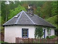
Former Tollhouse by the B8079, Allt Essan
Killiecrankie Toll House by the B8079 (old A9), in parish of Killiecrankie (Perth and Kinross District), Allt Essan, Killiecrankie.
HES Scotland Category C listed.
Reference: LB17695 http://portal.historicenvironment.scot/designation/LB17695
Surveyed
Milestone Society National ID: PK.KIK
Image: © Milestone Society
Taken: Unknown
0.00 miles
2
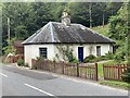
Allt Essan
Circa 1830. Single storey, 3-bay former toll house with centre ridge stack. Harled.
Grade C listed. Listing number LB17695.
Image: © Andrew Abbott
Taken: 17 Aug 2020
0.01 miles
3
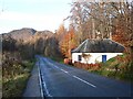
Cottage near Killecrankie
This cottage is on the old A9. It has hexagonal ends and looks like a toll house or lodge.
Image: © Rob Burke
Taken: 18 Nov 2006
0.01 miles
4
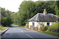
Allt Essan, Pass of Killiecrankie
Circa 1830. Single storey, 3-bay former toll house with centre ridge stack. Harled.
Grade C listed. Listing number LB17695
Image: © Andrew Abbott
Taken: 16 Aug 2020
0.01 miles
5
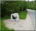
Boundary of Cairngorms National Park
The original 2003 park boundary was at Drumochter. This stone marks the new boundary in 2010, with an addition of Highland Perthshire and Glenshee. The Cairngorms National Park now covers 6 per cent of Scotland.
Image: © Russel Wills
Taken: 20 Jun 2011
0.02 miles
6
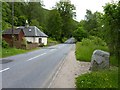
Old Toll House
This little building on General Wade's Military Road (now the B8019) was originally the Killiekrankie tollhouse.
Image: © James Allan
Taken: 27 Jun 2011
0.04 miles
7
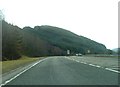
A9 by Killiecrankie, about to become Dual Carriageway
Image: © Peter Bond
Taken: 25 Feb 2012
0.05 miles
10
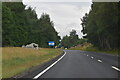
Killiecrankie - 1999
Killiecrankie, Perth and Kinross, Pass of Killiecrankie, B8079, General Wade's Military Road
Image: © Helmut Zozmann
Taken: 21 Jul 1999
0.11 miles