IMAGES TAKEN NEAR TO
Ferry Road, PITLOCHRY, PH16 5FL
Introduction
This page details the photographs taken nearby to Ferry Road, PH16 5FL by members of the Geograph project.
The Geograph project started in 2005 with the aim of publishing, organising and preserving representative images for every square kilometre of Great Britain, Ireland and the Isle of Man.

There are currently over 7.5m images from over14,400 individuals and you can help contribute to the project by visiting https://www.geograph.org.uk
Image Map
Images are licensed for reuse under creativecommons.org/licenses/by-sa/2.0
Notes
- Clicking on the map will re-center to the selected point.
- The higher the marker number, the further away the image location is from the centre of the postcode.
Image Listing (436 Images Found)
Images are licensed for reuse under creativecommons.org/licenses/by-sa/2.0
Image
Details
Distance
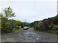
1
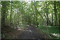
Woodland path, Pitlochry
Almost in the town centre.
Image: © Richard Webb
Taken: 20 Aug 2017
0.04 miles
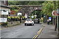
2
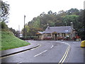
Drummond's Restaurant Ferry Rd Pitlochry
Image: © PAUL FARMER
Taken: 29 Sep 2009
0.04 miles
3
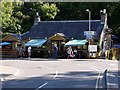
Drummonds Restaurant, Ferry Road, Pitlochry
Image: © Andrew Curtis
Taken: 9 Aug 2012
0.05 miles
4
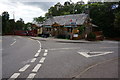
Drummonds Restaurant and Bar, Pitlochry
On Ferry Road.
Image: © jeff collins
Taken: 24 Aug 2014
0.05 miles
5
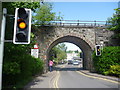
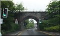
Perthshire Townscape : Railway Bridge Over Ferry Road, Pitlochry
Orange fruit pastille anyone?
Image: © Richard West
Taken: 25 May 2016
0.07 miles
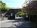
6
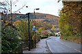
Ferry Road and path to the footbridge, Pitlochry
The signpost indicates the path to the suspension footbridge over the Tummel to the Festival Theatre and the fish ladder.
Image: © Jim Barton
Taken: 4 Nov 2016
0.08 miles