IMAGES TAKEN NEAR TO
East Moulin Road, PITLOCHRY, PH16 5ER
Introduction
This page details the photographs taken nearby to East Moulin Road, PH16 5ER by members of the Geograph project.
The Geograph project started in 2005 with the aim of publishing, organising and preserving representative images for every square kilometre of Great Britain, Ireland and the Isle of Man.

There are currently over 7.5m images from over14,400 individuals and you can help contribute to the project by visiting https://www.geograph.org.uk
Image Map
Images are licensed for reuse under creativecommons.org/licenses/by-sa/2.0
Notes
- Clicking on the map will re-center to the selected point.
- The higher the marker number, the further away the image location is from the centre of the postcode.
Image Listing (115 Images Found)
Images are licensed for reuse under creativecommons.org/licenses/by-sa/2.0
Image
Details
Distance
1
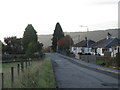
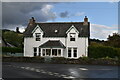
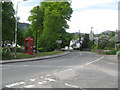
East Moulin Road, Pitlochry
Looking southwards from near the top of East Moulin Road on the north side of Pitlochry.
Image: © Scott Cormie
Taken: 2 Oct 2018
0.03 miles
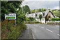
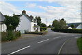
3
Minor road joins the A924 as it heads through Moulin
Image: © James Denham
Taken: 3 Jun 2010
0.06 miles
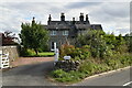
4
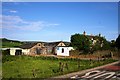
Joinery and Farm
A multi tasking farm on the outskirts of Pitlochry. Presumably with its land disappearing in new housing developments this farm also provides premises for a joinery business.
Image: © Andrew Wood
Taken: 1 Jun 2009
0.07 miles