IMAGES TAKEN NEAR TO
Manse Road, PITLOCHRY, PH16 5EP
Introduction
This page details the photographs taken nearby to Manse Road, PH16 5EP by members of the Geograph project.
The Geograph project started in 2005 with the aim of publishing, organising and preserving representative images for every square kilometre of Great Britain, Ireland and the Isle of Man.

There are currently over 7.5m images from over14,400 individuals and you can help contribute to the project by visiting https://www.geograph.org.uk
Image Map
Images are licensed for reuse under creativecommons.org/licenses/by-sa/2.0
Notes
- Clicking on the map will re-center to the selected point.
- The higher the marker number, the further away the image location is from the centre of the postcode.
Image Listing (124 Images Found)
Images are licensed for reuse under creativecommons.org/licenses/by-sa/2.0
Image
Details
Distance
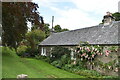
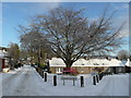
1
Manse Road and Moulin Square, Moulin
Image: © Douglas Nelson
Taken: 10 May 2015
0.03 miles
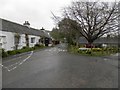
2
Moulin Bowling green
What's your preference beer or bowls?
Image: © Alan Stewart
Taken: 31 May 2008
0.04 miles
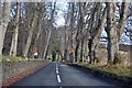
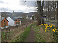
5

Avenue of limes, Moulin
Lime trees along the A924 seen from the driveway to Balnakeilly.
Image: © Richard Webb
Taken: 24 May 2009
0.08 miles
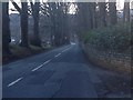
6
Entering Moulin
New houses on the left where the A924 enters the village.
Image: © Jim Barton
Taken: 10 Apr 2022
0.08 miles
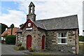
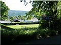
9
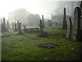
Graveyard: Moulin Kirk
The church closed for worship in 1989 and is now a heritage centre.
Image: © Jim Smillie
Taken: 6 Nov 2010
0.09 miles