IMAGES TAKEN NEAR TO
Kirkmichael Road, PITLOCHRY, PH16 5EH
Introduction
This page details the photographs taken nearby to Kirkmichael Road, PH16 5EH by members of the Geograph project.
The Geograph project started in 2005 with the aim of publishing, organising and preserving representative images for every square kilometre of Great Britain, Ireland and the Isle of Man.

There are currently over 7.5m images from over14,400 individuals and you can help contribute to the project by visiting https://www.geograph.org.uk
Image Map
Images are licensed for reuse under creativecommons.org/licenses/by-sa/2.0
Notes
- Clicking on the map will re-center to the selected point.
- The higher the marker number, the further away the image location is from the centre of the postcode.
Image Listing (126 Images Found)
Images are licensed for reuse under creativecommons.org/licenses/by-sa/2.0
Image
Details
Distance
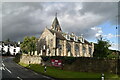
3
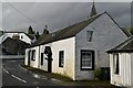
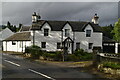
Moulin Hotel
An authentic Scottish highland hotel since 1695. Sited in the village square of Moulin, an ancient Scottish waypoint.
Image: © Maigheach-gheal
Taken: 21 May 2008
0.01 miles
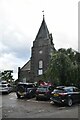
6
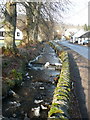
The Moulin Burn flows through Moulin
With ice on the banks and splashed rocks after another hard frost overnight.
Image: © Russel Wills
Taken: 13 Dec 2010
0.01 miles
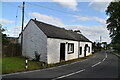
8
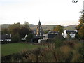
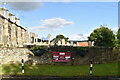
Village of Moulin
The village of Moulin on the north side of Pitlochry, viewed from the north on the A924.
Image: © Scott Cormie
Taken: 2 Oct 2018
0.02 miles