IMAGES TAKEN NEAR TO
Dunkeld Road, PERTH, PH1 5AL
Introduction
This page details the photographs taken nearby to Dunkeld Road, PH1 5AL by members of the Geograph project.
The Geograph project started in 2005 with the aim of publishing, organising and preserving representative images for every square kilometre of Great Britain, Ireland and the Isle of Man.

There are currently over 7.5m images from over14,400 individuals and you can help contribute to the project by visiting https://www.geograph.org.uk
Image Map
Images are licensed for reuse under creativecommons.org/licenses/by-sa/2.0
Notes
- Clicking on the map will re-center to the selected point.
- The higher the marker number, the further away the image location is from the centre of the postcode.
Image Listing (20 Images Found)
Images are licensed for reuse under creativecommons.org/licenses/by-sa/2.0
Image
Details
Distance
1
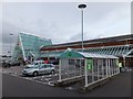
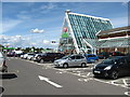
Car-park, trolley store and entrance, Asda, Perth
Image: © Alpin Stewart
Taken: 5 Oct 2014
0.06 miles
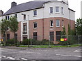
2
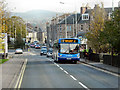
Crieff Road, Perth
Crieff Road (A85) approaching the junction with Dunkeld Road (A912).
Image: © David Dixon
Taken: 24 Oct 2011
0.07 miles
4
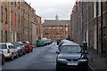
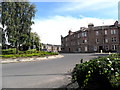
Inchaffray Street
Street of traditional tenements, the building at the far end is Balhousie Primary School.
Image: © Paul McIlroy
Taken: 26 Dec 2007
0.08 miles
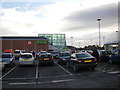
6
Car park and entrance to Asda store in Perth
Image: © James Denham
Taken: 31 Jul 2012
0.08 miles
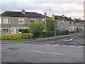
7
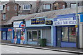
Crieff Road Chippie
This was here back in my day in the 70s.
Image: © william
Taken: 13 Jul 2010
0.09 miles
9
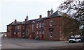
Muirton Regeneration
Tenement in Ainslie Place, Muirton.
Image: © Chris Barker
Taken: 14 Jun 2005
0.14 miles
10
Malvina Place
As far as I know, Argentina has not made any claims on this street in Perth.
Image: © william
Taken: 9 Sep 2011
0.15 miles