IMAGES TAKEN NEAR TO
Glenlyon, ABERFELDY, PH15 2PW
Introduction
This page details the photographs taken nearby to PH15 2PW by members of the Geograph project.
The Geograph project started in 2005 with the aim of publishing, organising and preserving representative images for every square kilometre of Great Britain, Ireland and the Isle of Man.

There are currently over 7.5m images from over14,400 individuals and you can help contribute to the project by visiting https://www.geograph.org.uk
Image Map
Images are licensed for reuse under creativecommons.org/licenses/by-sa/2.0
Notes
- Clicking on the map will re-center to the selected point.
- The higher the marker number, the further away the image location is from the centre of the postcode.
Image Listing (5 Images Found)
Images are licensed for reuse under creativecommons.org/licenses/by-sa/2.0
Image
Details
Distance
1
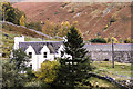
Farmhouse at Balnahanaid
Balnahanaid is a farm on the south side of Glen Lyon near to Camusvrachan; it's close to Allt a' Chobhair as it descends to join the River Lyon.
Image: © Trevor Littlewood
Taken: 23 Oct 1997
0.00 miles
2
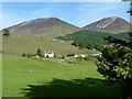
Balnahanaid Farm
Looking across Glen Lyon, over the farm at Balnahanaid, to the Corbett of Beinn Dearg (with its red screes) on the right, Creag Ard on the left and the Cul Lairig between them.
Image: © Richard Law
Taken: 3 Jun 2010
0.03 miles
3
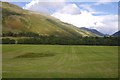
Floor of Glen Lyon
Fields at Balnahanaid.
Image: © Richard Webb
Taken: 4 Sep 2016
0.14 miles
4
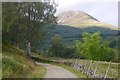
Road from Balnahanaid
A fine view of Beinn Dearg from the farm road.
Image: © Richard Webb
Taken: 4 Sep 2016
0.14 miles
5
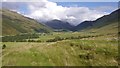
A view down Glen Lyon
On the track above Balnahanaid.
Image: © Richard Webb
Taken: 4 Sep 2016
0.24 miles