IMAGES TAKEN NEAR TO
Lawers, ABERFELDY, PH15 2PB
Introduction
This page details the photographs taken nearby to PH15 2PB by members of the Geograph project.
The Geograph project started in 2005 with the aim of publishing, organising and preserving representative images for every square kilometre of Great Britain, Ireland and the Isle of Man.

There are currently over 7.5m images from over14,400 individuals and you can help contribute to the project by visiting https://www.geograph.org.uk
Image Map
Images are licensed for reuse under creativecommons.org/licenses/by-sa/2.0
Notes
- Clicking on the map will re-center to the selected point.
- The higher the marker number, the further away the image location is from the centre of the postcode.
Image Listing (6 Images Found)
Images are licensed for reuse under creativecommons.org/licenses/by-sa/2.0
Image
Details
Distance
2
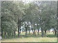
Birchwoods, Tombreck
A small birch wood amongst grassland on the sunny side of Loch Tay.
Image: © Richard Webb
Taken: 15 Aug 2011
0.11 miles
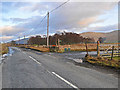
3
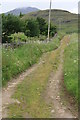
Start of the shieling track at Tombreck
Groups of shielings are scattered along the southern slopes of Ben Lawers.
Image: © Alan Reid
Taken: 17 Dec 2014
0.16 miles
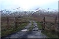
4
Ben Lawers track
Start of a track which leads up on to Ben Lawers, which can be seen in the background with cloud on the summit.
Image: © Colin Kinnear
Taken: 27 Jul 2010
0.18 miles
5
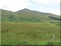
Southern slopes of Ben Lawers
Grassland above Tombreak, just before the steady 1000m climb to the top of Ben Lawers.
Image: © Richard Webb
Taken: 15 Aug 2011
0.19 miles