IMAGES TAKEN NEAR TO
Lawers, ABERFELDY, PH15 2PA
Introduction
This page details the photographs taken nearby to PH15 2PA by members of the Geograph project.
The Geograph project started in 2005 with the aim of publishing, organising and preserving representative images for every square kilometre of Great Britain, Ireland and the Isle of Man.

There are currently over 7.5m images from over14,400 individuals and you can help contribute to the project by visiting https://www.geograph.org.uk
Image Map
Images are licensed for reuse under creativecommons.org/licenses/by-sa/2.0
Notes
- Clicking on the map will re-center to the selected point.
- The higher the marker number, the further away the image location is from the centre of the postcode.
Image Listing (26 Images Found)
Images are licensed for reuse under creativecommons.org/licenses/by-sa/2.0
Image
Details
Distance
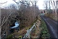
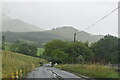
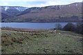
2
The road past Machuim
Loch Tay is just in the picture to the right, with the Ben Lawers range of hills out of the picture to the left.
Image: © Graham Ellis
Taken: 18 Feb 2007
0.07 miles
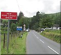
3
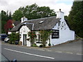
Souvenir Shop by Loch Tay
John Lacey's hand-carved horn souvenir shop by the side of the A827 near Lawers, on the north side of Loch Tay.
Image: © Gordon Elliott
Taken: 15 Sep 2009
0.09 miles
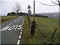
4
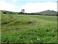
Grassland, Lawers
A grass crop on the slopes of Ben Lawers.
Image: © Richard Webb
Taken: 15 Aug 2011
0.09 miles
7
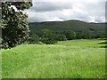
Grassland, Lawers
Fields between the road and Loch Tay.
Image: © Richard Webb
Taken: 15 Aug 2011
0.10 miles
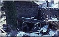
8
An old field boundary bank by Lawers Burn
Image: © Alan Reid
Taken: 17 Dec 2014
0.10 miles
9
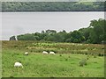
Fields above Loch Tay
Grassland and sheep at Lawers.
Image: © Richard Webb
Taken: 15 Aug 2011
0.12 miles