IMAGES TAKEN NEAR TO
Glenlyon, ABERFELDY, PH15 2NH
Introduction
This page details the photographs taken nearby to PH15 2NH by members of the Geograph project.
The Geograph project started in 2005 with the aim of publishing, organising and preserving representative images for every square kilometre of Great Britain, Ireland and the Isle of Man.

There are currently over 7.5m images from over14,400 individuals and you can help contribute to the project by visiting https://www.geograph.org.uk
Image Map
Images are licensed for reuse under creativecommons.org/licenses/by-sa/2.0
Notes
- Clicking on the map will re-center to the selected point.
- The higher the marker number, the further away the image location is from the centre of the postcode.
Image Listing (7 Images Found)
Images are licensed for reuse under creativecommons.org/licenses/by-sa/2.0
Image
Details
Distance
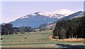
1
Chesthill, Glen Lyon
Chesthill was the home of Robert Campbell of Glenlyon who commanded the Campbells at the infamous Massacre of Glencoe in 1692. Creag Dhearg in the background.
Image: © Lisa Jarvis
Taken: 6 Jan 2007
0.07 miles
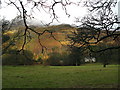
2
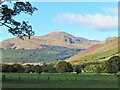
Glen Lyon at Chesthill
Looking up the glen across sheep pasture towards Meall Garbh and Carn Gorm
Image: © Gordon Hatton
Taken: 2 Apr 2009
0.15 miles
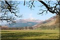
3
Glen Lyon, near Balintyre
The view up valley towards the snow capped Carn Gorm.
Image: © Gordon Hatton
Taken: Unknown
0.16 miles
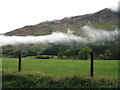
4
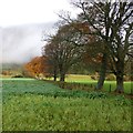
Field boundary, Chesthill
Autumn foliage and mist in Glen Lyon.
Image: © Alan O'Dowd
Taken: 9 Nov 2013
0.16 miles
5
Glen Lyon revisited
This must be a view I admire as it was taken from almost exactly the same spot as one nearly 12 years earlier. Just the autumnal colours make a difference to the scene.
Image: © Gordon Hatton
Taken: 13 Oct 2020
0.18 miles
6
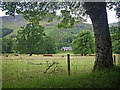
Chesthill viewed from the minor road
Photographer is standing quite close to the roadway edge.
Image: © C Michael Hogan
Taken: 10 Jul 2010
0.19 miles