IMAGES TAKEN NEAR TO
ABERFELDY, PH15 2LJ
Introduction
This page details the photographs taken nearby to PH15 2LJ by members of the Geograph project.
The Geograph project started in 2005 with the aim of publishing, organising and preserving representative images for every square kilometre of Great Britain, Ireland and the Isle of Man.

There are currently over 7.5m images from over14,400 individuals and you can help contribute to the project by visiting https://www.geograph.org.uk
Image Map
Images are licensed for reuse under creativecommons.org/licenses/by-sa/2.0
Notes
- Clicking on the map will re-center to the selected point.
- The higher the marker number, the further away the image location is from the centre of the postcode.
Image Listing (5 Images Found)
Images are licensed for reuse under creativecommons.org/licenses/by-sa/2.0
Image
Details
Distance
1
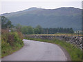
Graceful curve of the B846 Road flanked by drystane dyke
Photographer is standing on the road verge.
Image: © C Michael Hogan
Taken: 10 Jul 2010
0.06 miles
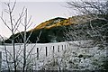
2
Farm gate with Creag a' Ghiubhais looking towards Garth
Gate on at the end of the farm track to the east of Tom na Croich
Image: © Anne Brennan
Taken: Unknown
0.13 miles
3
Creag a' Ghiubhais with Creag a' Chasteil behind
Looking North West from the farm track east of Tom na Croich, looking over Bal na Craig farm land
Image: © Anne Brennan
Taken: Unknown
0.22 miles
4
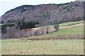
Fields at Tomnacroich
Below Creag a' Ghiuthais.
Image: © Alan Reid
Taken: 20 Dec 2019
0.24 miles
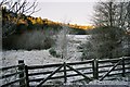
5
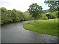
River Lyon
View downstream from the Duneaves footbridge.
Image: © Russel Wills
Taken: 20 May 2011
0.25 miles