IMAGES TAKEN NEAR TO
ABERFELDY, PH15 2JW
Introduction
This page details the photographs taken nearby to PH15 2JW by members of the Geograph project.
The Geograph project started in 2005 with the aim of publishing, organising and preserving representative images for every square kilometre of Great Britain, Ireland and the Isle of Man.

There are currently over 7.5m images from over14,400 individuals and you can help contribute to the project by visiting https://www.geograph.org.uk
Image Map
Images are licensed for reuse under creativecommons.org/licenses/by-sa/2.0
Notes
- Clicking on the map will re-center to the selected point.
- The higher the marker number, the further away the image location is from the centre of the postcode.
Image Listing (8 Images Found)
Images are licensed for reuse under creativecommons.org/licenses/by-sa/2.0
Image
Details
Distance
1
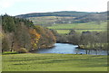
River Tay at Borlick
Downstream from General Wade's Bridge.
Image: © Russel Wills
Taken: 17 Nov 2009
0.12 miles
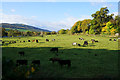
4
The edge of Boltachan Wood
Near Weem.
Image: © Andrew Abbott
Taken: 17 Aug 2020
0.23 miles
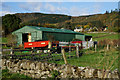
5
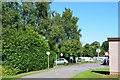
Aberfeldy Caravan Park
A caravan and camping site between the A827 and the River Tay.
Image: © Jim Barton
Taken: 6 Sep 2015
0.24 miles
6
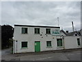
Fisher's Laundry, Aberfeldy
This building, on Home Street, was formerly a drill hall, used during WW1 by 6th Battalion, Black Watch (H Company) and 1 Scottish Horse (B Squadron).
Image: © Peter Barr
Taken: 26 Sep 2015
0.25 miles
7
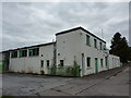
Fisher's Laundry, Aberfeldy
This building, on Home Street, was once the drill hall, during WW1, for 6th Battalion, Black Watch (H Company) and 1 Scottish Horse (B Squadron).
Image: © Peter Barr
Taken: 26 Sep 2015
0.25 miles
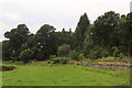
8
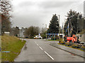
Aberfeldy
Entering Aberfeldy via the A827, Dunkeld Road (near the Caravan Park).
Image: © David Dixon
Taken: 24 Oct 2011
0.25 miles