IMAGES TAKEN NEAR TO
ABERFELDY, PH15 2JN
Introduction
This page details the photographs taken nearby to PH15 2JN by members of the Geograph project.
The Geograph project started in 2005 with the aim of publishing, organising and preserving representative images for every square kilometre of Great Britain, Ireland and the Isle of Man.

There are currently over 7.5m images from over14,400 individuals and you can help contribute to the project by visiting https://www.geograph.org.uk
Image Map
Images are licensed for reuse under creativecommons.org/licenses/by-sa/2.0
Notes
- Clicking on the map will re-center to the selected point.
- The higher the marker number, the further away the image location is from the centre of the postcode.
Image Listing (6 Images Found)
Images are licensed for reuse under creativecommons.org/licenses/by-sa/2.0
Image
Details
Distance
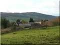
1
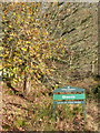
Upper Cuil Cottage, Boltachan
Track to Glassie Wood, part of the Tay Forest Park.
Image: © Lisa Jarvis
Taken: 6 Jan 2007
0.01 miles
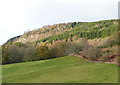
2
Upper Cuil Cottage
Distant views of the Glen Lyon mountains.
Image: © Russel Wills
Taken: 17 Nov 2009
0.01 miles
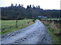
4
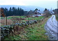
Cuil, Boltachan
Farm steadings overlooking Aberfeldy.
Image: © Lisa Jarvis
Taken: 6 Jan 2007
0.15 miles