IMAGES TAKEN NEAR TO
ABERFELDY, PH15 2HA
Introduction
This page details the photographs taken nearby to PH15 2HA by members of the Geograph project.
The Geograph project started in 2005 with the aim of publishing, organising and preserving representative images for every square kilometre of Great Britain, Ireland and the Isle of Man.

There are currently over 7.5m images from over14,400 individuals and you can help contribute to the project by visiting https://www.geograph.org.uk
Image Map
Images are licensed for reuse under creativecommons.org/licenses/by-sa/2.0
Notes
- Clicking on the map will re-center to the selected point.
- The higher the marker number, the further away the image location is from the centre of the postcode.
Image Listing (5 Images Found)
Images are licensed for reuse under creativecommons.org/licenses/by-sa/2.0
Image
Details
Distance
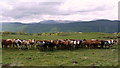
1
House above Kenmore
The edge of the inversion beside the Allt a' Bhealaich. Farragon Hill in the background.
Image: © Richard Webb
Taken: 9 Nov 2014
0.01 miles
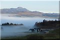
2
Bridge on track north of Tombuie Cottage
Image: © Andrew Curtis
Taken: 17 May 2009
0.10 miles
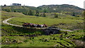
3
Track, Braes of Taymouth
Part of the Rob Roy Way, taking a contouring route towards Aberfeldy that gives fine views of Strath Tay.
Image: © Jim Barton
Taken: 17 Mar 2016
0.11 miles
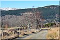
4
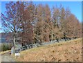
Rob Roy Way, Braes of Taymouth
The Way keeps outside the boundary wall of the plantation, unlike the marking on the 1:25,000 map.
Image: © Jim Barton
Taken: 17 Mar 2016
0.13 miles