IMAGES TAKEN NEAR TO
ABERFELDY, PH15 2DZ
Introduction
This page details the photographs taken nearby to PH15 2DZ by members of the Geograph project.
The Geograph project started in 2005 with the aim of publishing, organising and preserving representative images for every square kilometre of Great Britain, Ireland and the Isle of Man.

There are currently over 7.5m images from over14,400 individuals and you can help contribute to the project by visiting https://www.geograph.org.uk
Image Map
Images are licensed for reuse under creativecommons.org/licenses/by-sa/2.0
Notes
- Clicking on the map will re-center to the selected point.
- The higher the marker number, the further away the image location is from the centre of the postcode.
Image Listing (5 Images Found)
Images are licensed for reuse under creativecommons.org/licenses/by-sa/2.0
Image
Details
Distance
1
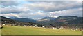
Across the fields to Aberfeldy
A view towards the town from the track linking Borlick with the old Crieff road.
Image: © Gordon Hatton
Taken: 31 Mar 2009
0.13 miles
2
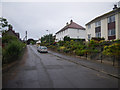
Looking upward on an Aberfeldy residential street
Image: © C Michael Hogan
Taken: 10 Jul 2010
0.20 miles
3
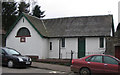
Masonic Lodge, Aberfeldy
A notice over the door identifies this as the Breadalbane Lodge.
Image: © David Greenhalgh
Taken: 15 Apr 2006
0.21 miles
5
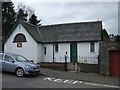
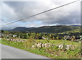
Masonic Hall, Aberfeldy
Looking south-west.
Image: © Kenneth Allen
Taken: 22 Apr 2008
0.24 miles