IMAGES TAKEN NEAR TO
Stanley, PERTH, PH1 4QQ
Introduction
This page details the photographs taken nearby to PH1 4QQ by members of the Geograph project.
The Geograph project started in 2005 with the aim of publishing, organising and preserving representative images for every square kilometre of Great Britain, Ireland and the Isle of Man.

There are currently over 7.5m images from over14,400 individuals and you can help contribute to the project by visiting https://www.geograph.org.uk
Image Map
Images are licensed for reuse under creativecommons.org/licenses/by-sa/2.0
Notes
- Clicking on the map will re-center to the selected point.
- The higher the marker number, the further away the image location is from the centre of the postcode.
Image Listing (4 Images Found)
Images are licensed for reuse under creativecommons.org/licenses/by-sa/2.0
Image
Details
Distance
1
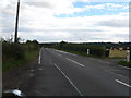
Country road heading away, off the B9099 at West Tofts
North of the village of Stanley in Perthshire.
Image: © James Denham
Taken: 26 Sep 2012
0.16 miles
2
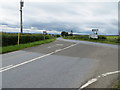
Road joining B9099 near South View
Looking south-westward.
Image: © Peter Wood
Taken: 4 Jul 2020
0.17 miles
3
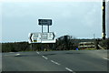
Junction at West Tofts, near Stanley
The road from Stanley to Caputh is a B road but less well-used than the unclassified road, used as a route from Perth to Blairgowrie.
Image: © Mike Pennington
Taken: 5 Apr 2011
0.17 miles
4
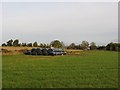
Silage store, West Tofts
More round bales stored for fodder.
Image: © Richard Webb
Taken: 29 Oct 2006
0.19 miles