IMAGES TAKEN NEAR TO
Stanley, PERTH, PH1 4QP
Introduction
This page details the photographs taken nearby to PH1 4QP by members of the Geograph project.
The Geograph project started in 2005 with the aim of publishing, organising and preserving representative images for every square kilometre of Great Britain, Ireland and the Isle of Man.

There are currently over 7.5m images from over14,400 individuals and you can help contribute to the project by visiting https://www.geograph.org.uk
Image Map
Images are licensed for reuse under creativecommons.org/licenses/by-sa/2.0
Notes
- Clicking on the map will re-center to the selected point.
- The higher the marker number, the further away the image location is from the centre of the postcode.
Image Listing (3 Images Found)
Images are licensed for reuse under creativecommons.org/licenses/by-sa/2.0
Image
Details
Distance
2
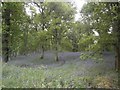
Bluebell Woods At Kinclaven
Bluebell Woods Next To Kinclaven, Perthire In Scotland.
http://www.facebook.com/stevanhogg1
Image: © Stevan Hogg
Taken: 5 Jun 2013
0.10 miles
3
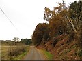
Road off the Haughs
The road runs beside a marshy area which looks to be a former course of the Tay. The woods are on a sandy hillside.
Image: © Richard Webb
Taken: 30 Nov 2013
0.15 miles