IMAGES TAKEN NEAR TO
Stanley, PERTH, PH1 4PN
Introduction
This page details the photographs taken nearby to PH1 4PN by members of the Geograph project.
The Geograph project started in 2005 with the aim of publishing, organising and preserving representative images for every square kilometre of Great Britain, Ireland and the Isle of Man.

There are currently over 7.5m images from over14,400 individuals and you can help contribute to the project by visiting https://www.geograph.org.uk
Image Map
Images are licensed for reuse under creativecommons.org/licenses/by-sa/2.0
Notes
- Clicking on the map will re-center to the selected point.
- The higher the marker number, the further away the image location is from the centre of the postcode.
Image Listing (3 Images Found)
Images are licensed for reuse under creativecommons.org/licenses/by-sa/2.0
Image
Details
Distance
1
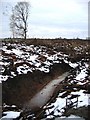
Half a Tree
Not too sure if this tree got lopped as Charleston wood was cleared or if it just grew that way, being up against a forest. Looks a bit weird on its own now.
Image: © Keith Proven
Taken: 5 Jan 2006
0.12 miles
2
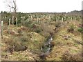
Charleston Wood
Taken five years on from Image, the ditch has filled somewhat and the next generation of trees are snug in their Tuley tubes.
Image: © Richard Webb
Taken: 15 Feb 2011
0.16 miles
3
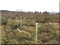
Charleston Wood
Felled before 2006, now replanted.
Image: © Richard Webb
Taken: 15 Feb 2011
0.17 miles