IMAGES TAKEN NEAR TO
Caputh, PERTH, PH1 4JL
Introduction
This page details the photographs taken nearby to PH1 4JL by members of the Geograph project.
The Geograph project started in 2005 with the aim of publishing, organising and preserving representative images for every square kilometre of Great Britain, Ireland and the Isle of Man.

There are currently over 7.5m images from over14,400 individuals and you can help contribute to the project by visiting https://www.geograph.org.uk
Image Map
Images are licensed for reuse under creativecommons.org/licenses/by-sa/2.0
Notes
- Clicking on the map will re-center to the selected point.
- The higher the marker number, the further away the image location is from the centre of the postcode.
Image Listing (8 Images Found)
Images are licensed for reuse under creativecommons.org/licenses/by-sa/2.0
Image
Details
Distance
3
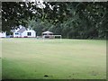
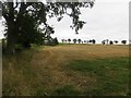
Goal at Glendelvine School
Football pitch at Glendelvine Primary School, viewed from the A984 road near Caputh.
Image: © Scott Cormie
Taken: 30 Jul 2019
0.16 miles
4
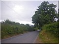
Approaching Blackhillock
Berming on both sides of the road, topped with shrub and tree, yields a tunnel-like effect.
Image: © C Michael Hogan
Taken: 28 Jul 2012
0.16 miles
5
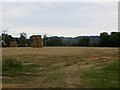
Forehill
Big square bales await collection.
Image: © Richard Webb
Taken: 6 Sep 2013
0.17 miles