IMAGES TAKEN NEAR TO
Murthly, PERTH, PH1 4HB
Introduction
This page details the photographs taken nearby to PH1 4HB by members of the Geograph project.
The Geograph project started in 2005 with the aim of publishing, organising and preserving representative images for every square kilometre of Great Britain, Ireland and the Isle of Man.

There are currently over 7.5m images from over14,400 individuals and you can help contribute to the project by visiting https://www.geograph.org.uk
Image Map
Images are licensed for reuse under creativecommons.org/licenses/by-sa/2.0
Notes
- Clicking on the map will re-center to the selected point.
- The higher the marker number, the further away the image location is from the centre of the postcode.
Image Listing (4 Images Found)
Images are licensed for reuse under creativecommons.org/licenses/by-sa/2.0
Image
Details
Distance
2
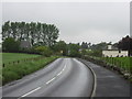
B9099 approaching Murthly
The B9099 approaching the village of Murthly from the south.
Image: © Scott Cormie
Taken: 19 May 2019
0.20 miles
3
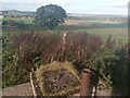
The Waters Under the Earth
Taken at Ardoch farm, highest point in the village of Murthly. Standing on the concrete cap of the old resevoir, looking towards a big old oak tree. Which guards a deep, brick-lined well. In the distance to the right, half hidden by shrubbery is an old wooden door. This opens into a large cistern. The holding tank for Murthly Lunatic Asylum's water supply, built in 1864. Springs and wells at Ardoch were vital to the development of the village.
Out of shot to the left is Murthly Primary School, and a strip of houses along the B9099. After a rainy spell, residents are often kept awake by the sound of water rushing under them through forgotten channels and drains.
Image: © Paul McLennan
Taken: 11 Oct 2023
0.21 miles
4
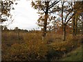
Forest edge
Oak woods on the eastern edge of a large forest centred on Thorn Muir.
Image: © Richard Webb
Taken: 12 Nov 2006
0.22 miles