IMAGES TAKEN NEAR TO
Bankfoot, PERTH, PH1 4DW
Introduction
This page details the photographs taken nearby to PH1 4DW by members of the Geograph project.
The Geograph project started in 2005 with the aim of publishing, organising and preserving representative images for every square kilometre of Great Britain, Ireland and the Isle of Man.

There are currently over 7.5m images from over14,400 individuals and you can help contribute to the project by visiting https://www.geograph.org.uk
Image Map
Images are licensed for reuse under creativecommons.org/licenses/by-sa/2.0
Notes
- Clicking on the map will re-center to the selected point.
- The higher the marker number, the further away the image location is from the centre of the postcode.
Image Listing (6 Images Found)
Images are licensed for reuse under creativecommons.org/licenses/by-sa/2.0
Image
Details
Distance
1

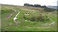
Corrielea
Ruined steading, Tullybelton. An old electricity transformer tells of this being once connected to the grid.
Image: © Richard Webb
Taken: 21 Sep 2008
0.04 miles
2
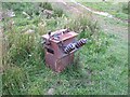
Transformer, Corrielea
Abandoned electrical equipment, rusting at Corrielea.
Image: © Richard Webb
Taken: 21 Sep 2008
0.05 miles
3
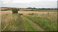
Track bend, Corrielea
The track bends and continues further up the hill than is shown on the maps.
Image: © Richard Webb
Taken: 21 Sep 2008
0.06 miles
4
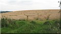
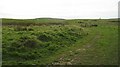
Barley, Corrielea
Some unwanted visitors have been by, judging by the tracks in the crop. Probably deer.
Image: © Richard Webb
Taken: 21 Sep 2008
0.11 miles