IMAGES TAKEN NEAR TO
Graham Court, PERTH, PH1 4DS
Introduction
This page details the photographs taken nearby to Graham Court, PH1 4DS by members of the Geograph project.
The Geograph project started in 2005 with the aim of publishing, organising and preserving representative images for every square kilometre of Great Britain, Ireland and the Isle of Man.

There are currently over 7.5m images from over14,400 individuals and you can help contribute to the project by visiting https://www.geograph.org.uk
Image Map
Images are licensed for reuse under creativecommons.org/licenses/by-sa/2.0
Notes
- Clicking on the map will re-center to the selected point.
- The higher the marker number, the further away the image location is from the centre of the postcode.
Image Listing (39 Images Found)
Images are licensed for reuse under creativecommons.org/licenses/by-sa/2.0
Image
Details
Distance
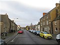
1
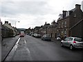
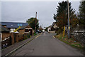
Main Street, Bankfoot
Looking northwards along the old A9.
Image: © Richard Webb
Taken: 18 Jul 2011
0.04 miles
2
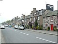
Bankfoot main street
Looking north, with the Bankfoot Inn on the right.
Image: © James Allan
Taken: 4 May 2007
0.05 miles
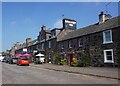
3
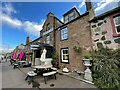
Bankfoot Inn
On Main Street, Bankfoot - once the A9.
Image: © Richard Webb
Taken: 30 Nov 2013
0.06 miles
5
The Bankfoot Inn
Hotel and restaurant on the main street in the village
Image: © Graham Hogg
Taken: 14 Jun 2021
0.07 miles
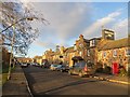
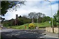
7
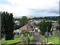
Bankfoot village
Seen from the mound upon which the ruins of the old church, destroyed by fire in 2004, stands.
Image: © David Purchase
Taken: 7 Aug 2012
0.09 miles
9
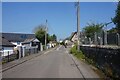
Bankfoot
The main road through the village, once the A9.
Image: © Richard Webb
Taken: 30 Nov 2013
0.12 miles
10
Auchtergaven Church
Auchtergaven Church before the fire
Image: © Alistair Bell
Taken: 14 May 2003
0.13 miles