IMAGES TAKEN NEAR TO
Coxland Crescent, PERTH, PH1 4DF
Introduction
This page details the photographs taken nearby to Coxland Crescent, PH1 4DF by members of the Geograph project.
The Geograph project started in 2005 with the aim of publishing, organising and preserving representative images for every square kilometre of Great Britain, Ireland and the Isle of Man.

There are currently over 7.5m images from over14,400 individuals and you can help contribute to the project by visiting https://www.geograph.org.uk
Image Map
Images are licensed for reuse under creativecommons.org/licenses/by-sa/2.0
Notes
- Clicking on the map will re-center to the selected point.
- The higher the marker number, the further away the image location is from the centre of the postcode.
Image Listing (12 Images Found)
Images are licensed for reuse under creativecommons.org/licenses/by-sa/2.0
Image
Details
Distance
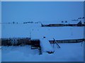
1
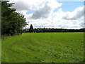
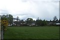
The southern edge of Bankfoot
Scot's Wood is on the right.
Image: © David Purchase
Taken: 7 Aug 2012
0.03 miles
2
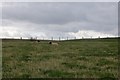
Field, Bankfoot
Suffolks on the edge of Bankfoot.
Image: © Richard Webb
Taken: 29 Aug 2015
0.08 miles
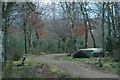
3
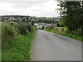
Road to Bankfoot
Minor road heading to Bankfoot from the south-west.
Image: © Scott Cormie
Taken: 18 Sep 2022
0.10 miles
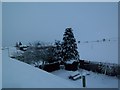
6
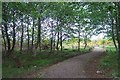
Millennium Walk
"Big Stone" at Millennium Walk near old School House.
Image: © Alistair Bell
Taken: 1 Feb 2007
0.12 miles
7
Auchtergaven Primary School
Prieston Road Towards Coxland Farm.
Image: © Alistair Bell
Taken: 26 Oct 2006
0.20 miles
8
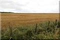
Barley, Bankfoot
A field in a road fork near Bankfoot.
Image: © Richard Webb
Taken: 29 Aug 2015
0.20 miles
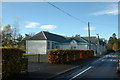
9
Auchtergaven Primary School
Auchtergaven Primary School from rear at the start of the millennium walk.
Image: © Alistair Bell
Taken: 14 May 2003
0.21 miles
10
Millennium Walk
Millennium Walk within moor facing south
Image: © Alistair Bell
Taken: 14 May 2003
0.22 miles