IMAGES TAKEN NEAR TO
Bankfoot, PERTH, PH1 4BY
Introduction
This page details the photographs taken nearby to PH1 4BY by members of the Geograph project.
The Geograph project started in 2005 with the aim of publishing, organising and preserving representative images for every square kilometre of Great Britain, Ireland and the Isle of Man.

There are currently over 7.5m images from over14,400 individuals and you can help contribute to the project by visiting https://www.geograph.org.uk
Image Map
Images are licensed for reuse under creativecommons.org/licenses/by-sa/2.0
Notes
- Clicking on the map will re-center to the selected point.
- The higher the marker number, the further away the image location is from the centre of the postcode.
Image Listing (6 Images Found)
Images are licensed for reuse under creativecommons.org/licenses/by-sa/2.0
Image
Details
Distance
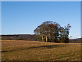
1
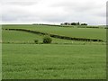
Over Blelock
Farm surrounded by arable land.
Image: © Richard Webb
Taken: 20 May 2007
0.04 miles
2
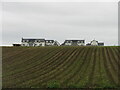
Over Blelock
New builds at Over Blelock viewed over farmland from the south-east.
Image: © Scott Cormie
Taken: 18 Sep 2022
0.04 miles
3
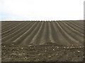
Over Blelock
Tattie rigs at planting time.
Image: © Richard Webb
Taken: 20 May 2007
0.16 miles
4
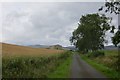
Road to Farkhill
One of the roads radiating from Bankfoot. As so often in Perthshire, great lengths have been taken against parking but this tactic fails against bikes.
Image: © Richard Webb
Taken: 29 Aug 2015
0.21 miles
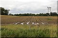
5
Farmland near Farkhill
Farmland near Farkhill - now drab in appearance on a December afternoon.
Image: © William Starkey
Taken: 15 Dec 2011
0.22 miles
6
Potato crop, Bankfoot
Defoliated and awaiting lifting.
Image: © Richard Webb
Taken: 29 Aug 2015
0.23 miles