IMAGES TAKEN NEAR TO
Carriers Entry, PERTH, PH1 4BA
Introduction
This page details the photographs taken nearby to Carriers Entry, PH1 4BA by members of the Geograph project.
The Geograph project started in 2005 with the aim of publishing, organising and preserving representative images for every square kilometre of Great Britain, Ireland and the Isle of Man.

There are currently over 7.5m images from over14,400 individuals and you can help contribute to the project by visiting https://www.geograph.org.uk
Image Map
Images are licensed for reuse under creativecommons.org/licenses/by-sa/2.0
Notes
- Clicking on the map will re-center to the selected point.
- The higher the marker number, the further away the image location is from the centre of the postcode.
Image Listing (33 Images Found)
Images are licensed for reuse under creativecommons.org/licenses/by-sa/2.0
Image
Details
Distance
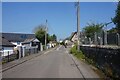
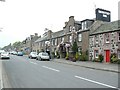
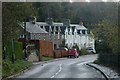
1
Bankfoot
The main road through the village, once the A9.
Image: © Richard Webb
Taken: 30 Nov 2013
0.02 miles
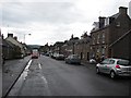
2
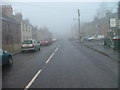
Bankfoot Main Street
Looking northwest on a cold and frosty Christmas Eve.
Image: © Dave Fergusson
Taken: 24 Dec 2006
0.04 miles
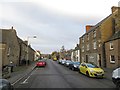
3
Bankfoot Main Street
This was the old A9 trunk road before the new one was built to bypass the village.
Image: © Dave Fergusson
Taken: 24 Dec 2006
0.05 miles
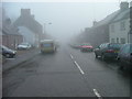
5
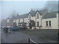
The Atholl Hotel, Bankfoot
On a freezing and foggy Christmas Eve.
Image: © Dave Fergusson
Taken: 24 Dec 2006
0.06 miles
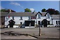
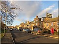
6
Bankfoot main street
Looking north, with the Bankfoot Inn on the right.
Image: © James Allan
Taken: 4 May 2007
0.07 miles
7
Main Street, Bankfoot
Looking northwards along the old A9.
Image: © Richard Webb
Taken: 18 Jul 2011
0.12 miles
8
Dunkeld Road Bankfoot
Dunkeld Road facing South.
Image: © Alistair Bell
Taken: 1 Feb 2007
0.13 miles
9
Bankfoot Inn
On Main Street, Bankfoot - once the A9.
Image: © Richard Webb
Taken: 30 Nov 2013
0.13 miles