IMAGES TAKEN NEAR TO
Bankfoot, PERTH, PH1 4AR
Introduction
This page details the photographs taken nearby to PH1 4AR by members of the Geograph project.
The Geograph project started in 2005 with the aim of publishing, organising and preserving representative images for every square kilometre of Great Britain, Ireland and the Isle of Man.

There are currently over 7.5m images from over14,400 individuals and you can help contribute to the project by visiting https://www.geograph.org.uk
Image Map
Images are licensed for reuse under creativecommons.org/licenses/by-sa/2.0
Notes
- Clicking on the map will re-center to the selected point.
- The higher the marker number, the further away the image location is from the centre of the postcode.
Image Listing (6 Images Found)
Images are licensed for reuse under creativecommons.org/licenses/by-sa/2.0
Image
Details
Distance
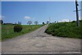
4
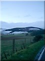
The old A9
The former A9 climbs to the Pass of Birnam. Now this twisty road has been replaced by a new road to the east. Image
Image: © Richard Webb
Taken: 18 Jul 2011
0.14 miles
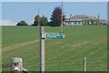
5
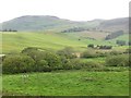
Looking towards Obney Hills
Taken towards dusk, just north of Waterloo.
Image: © Kirsty Smith
Taken: 25 Nov 2005
0.24 miles
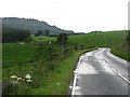
6
Corral Burn
Wetland surrounding the Corral Burn.
Image: © Richard Webb
Taken: 18 Jul 2011
0.24 miles