IMAGES TAKEN NEAR TO
Lochty Park, PERTH, PH1 3XZ
Introduction
This page details the photographs taken nearby to Lochty Park, PH1 3XZ by members of the Geograph project.
The Geograph project started in 2005 with the aim of publishing, organising and preserving representative images for every square kilometre of Great Britain, Ireland and the Isle of Man.

There are currently over 7.5m images from over14,400 individuals and you can help contribute to the project by visiting https://www.geograph.org.uk
Image Map (Loading...)


Getting Data...Please wait
Leaflet Map data © OpenStreetMap
Images are licensed for reuse under creativecommons.org/licenses/by-sa/2.0
Notes
- Clicking on the map will re-center to the selected point.
- The higher the marker number, the further away the image location is from the centre of the postcode.
Image Listing (6 Images Found)
Images are licensed for reuse under creativecommons.org/licenses/by-sa/2.0
Image
Details
Distance
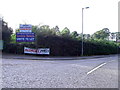
2
Housing at the side of the A85, Perth to Crieff road
At the small village of Lochty.
Image: © James Denham
Taken: 23 Jul 2013
0.09 miles
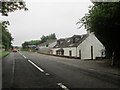
3
A85, Lochty
The A85, entering Lochty from the west.
Image: © David Dixon
Taken: 24 Oct 2011
0.13 miles
4
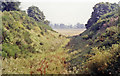
Trackbed of Caledonian Railway at Almondbank, 1991
View eastward, towards Perth: ex-CR Perth (Almond Valley Junction) - Crieff - Balquhidder line, which was closed west of Crieff from 1/10/51 but remained open for goods until 9/67. (The station site was probably behind me, the other side of the main road bridge.)
Image: © Ben Brooksbank
Taken: 4 Sep 1991
0.13 miles
5
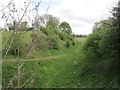
Perth, Almond Valley and Methven Railway
A cutting near Methven. The bridge carrying the A85 has been replaced by an embankment. The other side of the embankment is now a garden.
Image: © Richard Webb
Taken: 16 May 2013
0.15 miles
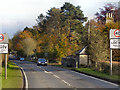
6
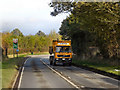
A85, Near Lochty
The lorry is travelling west on the A85, having just passed through Lochty
Image: © David Dixon
Taken: 24 Oct 2011
0.20 miles