IMAGES TAKEN NEAR TO
West Huntingtower, PERTH, PH1 3NU
Introduction
This page details the photographs taken nearby to PH1 3NU by members of the Geograph project.
The Geograph project started in 2005 with the aim of publishing, organising and preserving representative images for every square kilometre of Great Britain, Ireland and the Isle of Man.

There are currently over 7.5m images from over14,400 individuals and you can help contribute to the project by visiting https://www.geograph.org.uk
Image Map
Images are licensed for reuse under creativecommons.org/licenses/by-sa/2.0
Notes
- Clicking on the map will re-center to the selected point.
- The higher the marker number, the further away the image location is from the centre of the postcode.
Image Listing (8 Images Found)
Images are licensed for reuse under creativecommons.org/licenses/by-sa/2.0
Image
Details
Distance
1
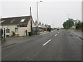
Looking east at Huntingtower in Perthshire
The tiny hamlet is situated near the mighty Huntingtower Castle.
Image: © James Denham
Taken: 23 Jul 2013
0.02 miles
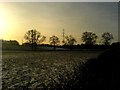
3
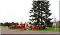
Farm machinery, Huntingtower near Perth
Image: © nick macneill
Taken: 4 Sep 2011
0.10 miles
4
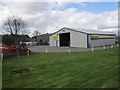
Agricar Ltd
New Holland dealership, Huntingtower.
Image: © Richard Webb
Taken: 16 May 2013
0.10 miles
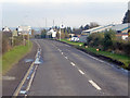
5
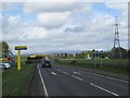
A85, Huntingtower
Passing Agricar looking towards a garage.
Image: © Richard Webb
Taken: 16 May 2013
0.14 miles
7
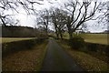
Drive, West Mains
This elegant private road is signposted as a cycle path as well as the usual green core path sign.
Image: © Richard Webb
Taken: 15 Dec 2016
0.21 miles
8
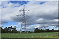
Power line, Huntingtower
The power line which runs from Kincardine (and before that, Denny), over the Ochils and up Strathmore to Inverurie.
Image: © Richard Webb
Taken: 24 May 2015
0.24 miles