IMAGES TAKEN NEAR TO
Bridgeton Place, PERTH, PH1 3ND
Introduction
This page details the photographs taken nearby to Bridgeton Place, PH1 3ND by members of the Geograph project.
The Geograph project started in 2005 with the aim of publishing, organising and preserving representative images for every square kilometre of Great Britain, Ireland and the Isle of Man.

There are currently over 7.5m images from over14,400 individuals and you can help contribute to the project by visiting https://www.geograph.org.uk
Image Map
Images are licensed for reuse under creativecommons.org/licenses/by-sa/2.0
Notes
- Clicking on the map will re-center to the selected point.
- The higher the marker number, the further away the image location is from the centre of the postcode.
Image Listing (6 Images Found)
Images are licensed for reuse under creativecommons.org/licenses/by-sa/2.0
Image
Details
Distance
2
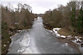
Frozen River Almond
Taken from the bridge at Almondbank, looking downstream. There are footprints on the ice.
Image: © Rob Burke
Taken: 27 Feb 2010
0.07 miles
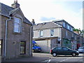
3

Satellite dishes and telephone box
On the main street of Almondbank.
Image: © Dave Fergusson
Taken: 31 Mar 2011
0.20 miles
6
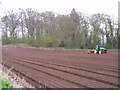
Spring Sowing
This picture shows the field at the east of the Bridgeton Housing estate being sown with turnips.
Image: © Arthur Bruce
Taken: Unknown
0.25 miles