IMAGES TAKEN NEAR TO
Burrelton, BLAIRGOWRIE, PH13 9PY
Introduction
This page details the photographs taken nearby to PH13 9PY by members of the Geograph project.
The Geograph project started in 2005 with the aim of publishing, organising and preserving representative images for every square kilometre of Great Britain, Ireland and the Isle of Man.

There are currently over 7.5m images from over14,400 individuals and you can help contribute to the project by visiting https://www.geograph.org.uk
Image Map
Images are licensed for reuse under creativecommons.org/licenses/by-sa/2.0
Notes
- Clicking on the map will re-center to the selected point.
- The higher the marker number, the further away the image location is from the centre of the postcode.
Image Listing (7 Images Found)
Images are licensed for reuse under creativecommons.org/licenses/by-sa/2.0
Image
Details
Distance
2
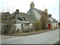
Abandoned cottage
A deserted and dilapidated cottage in the hamlet of Strelitz
Image: © James Allan
Taken: 18 Mar 2006
0.05 miles
3
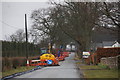
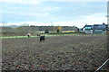
Roadworks at Strelitz, Burrelton
Installing a water pipe.
Image: © Mike Pennington
Taken: 7 Apr 2013
0.05 miles
4
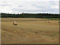
Round bales near Strelitz
Strelitz Wood in the background.
Image: © Richard Webb
Taken: 6 Sep 2013
0.08 miles
5
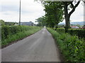
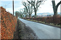
The road to Burrelton
Long straight heading to Burrelton from Strelitz.
Image: © Scott Cormie
Taken: 17 Jun 2018
0.13 miles
7
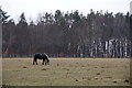
Horse in a field, Whitelea Road, Burrelton
Image: © Mike Pennington
Taken: 7 Apr 2013
0.23 miles