IMAGES TAKEN NEAR TO
Burrelton, BLAIRGOWRIE, PH13 9PS
Introduction
This page details the photographs taken nearby to PH13 9PS by members of the Geograph project.
The Geograph project started in 2005 with the aim of publishing, organising and preserving representative images for every square kilometre of Great Britain, Ireland and the Isle of Man.

There are currently over 7.5m images from over14,400 individuals and you can help contribute to the project by visiting https://www.geograph.org.uk
Image Map
Images are licensed for reuse under creativecommons.org/licenses/by-sa/2.0
Notes
- Clicking on the map will re-center to the selected point.
- The higher the marker number, the further away the image location is from the centre of the postcode.
Image Listing (6 Images Found)
Images are licensed for reuse under creativecommons.org/licenses/by-sa/2.0
Image
Details
Distance
1
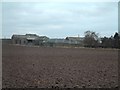
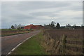
East Whitefield farm
The flat land around Whitefield was used during and shortly after WW2 as a relief landing ground for training aircraft operating from Perth (Scone) aerodrome
Image: © James Allan
Taken: 18 Feb 2006
0.07 miles
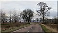
2
East Whitefield Farm
There are several 'Whitefield' Farms here. Confusingly, this one is marked as 'East Whitefield' on the map, but as merely 'Whitefield' at the road end.
Image: © Becky Williamson
Taken: 11 Apr 2012
0.11 miles
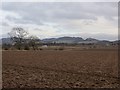
6
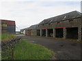
Steadings at Meikle Whitefield
Farm buildings at Meikle Whitefield.
Image: © Scott Cormie
Taken: 17 Jun 2018
0.24 miles