IMAGES TAKEN NEAR TO
Burrelton, BLAIRGOWRIE, PH13 9PP
Introduction
This page details the photographs taken nearby to PH13 9PP by members of the Geograph project.
The Geograph project started in 2005 with the aim of publishing, organising and preserving representative images for every square kilometre of Great Britain, Ireland and the Isle of Man.

There are currently over 7.5m images from over14,400 individuals and you can help contribute to the project by visiting https://www.geograph.org.uk
Image Map
Images are licensed for reuse under creativecommons.org/licenses/by-sa/2.0
Notes
- Clicking on the map will re-center to the selected point.
- The higher the marker number, the further away the image location is from the centre of the postcode.
Image Listing (3 Images Found)
Images are licensed for reuse under creativecommons.org/licenses/by-sa/2.0
Image
Details
Distance
1
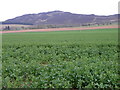
Oilseed rape, Saucher
Oilseed rape is the third important crop in the UK after wheat and barley. It can be either winter or spring sown. Winter sown oilseed rape is primarily grown for its oil, which is used in cooking and food processing.
Image: © Maigheach-gheal
Taken: 15 Apr 2011
0.19 miles
2
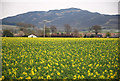
Field of Rape Seed
The pungent yellow flowers make quite a spectacle in the Perthshire countryside.
The West Sidlaw Hill Range is seen in the background..
Image: © Glen Breaden
Taken: 18 Apr 2011
0.25 miles
3
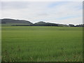
Field near Collace
Green field to the north of Collace, with Dunsinane Hill in the distance.
Image: © Scott Cormie
Taken: 17 Jun 2018
0.25 miles