IMAGES TAKEN NEAR TO
Woodside, BLAIRGOWRIE, PH13 9NQ
Introduction
This page details the photographs taken nearby to PH13 9NQ by members of the Geograph project.
The Geograph project started in 2005 with the aim of publishing, organising and preserving representative images for every square kilometre of Great Britain, Ireland and the Isle of Man.

There are currently over 7.5m images from over14,400 individuals and you can help contribute to the project by visiting https://www.geograph.org.uk
Image Map
Images are licensed for reuse under creativecommons.org/licenses/by-sa/2.0
Notes
- Clicking on the map will re-center to the selected point.
- The higher the marker number, the further away the image location is from the centre of the postcode.
Image Listing (11 Images Found)
Images are licensed for reuse under creativecommons.org/licenses/by-sa/2.0
Image
Details
Distance
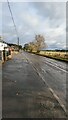
1
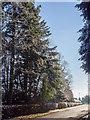
Station Road, Woodside
Tall trees dusted with snow. They are on the boundary to a large garden east of Station Road. The station and railway are long gone.
Image: © Rob Burke
Taken: 15 Jan 2013
0.02 miles
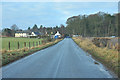
2
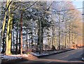
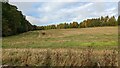
Roadside trees
A small area of woodland next to the road in Woodside
Image: © Lis Burke
Taken: 15 Jan 2013
0.03 miles
3
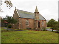
Cargill-Burrelton Church, Woodside
Viewed from the south-west.
Image: © Peter Wood
Taken: 16 Nov 2019
0.12 miles
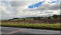
8
A94 at Woodside
The A94 heading out of Woodside, bound for Coupar Angus.
Image: © Scott Cormie
Taken: 12 May 2018
0.19 miles
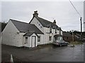
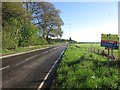
10
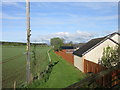
Former line of railway
The old line of the railway through Strathmore, now partly covered in housing and used a path to Burrelton.
Image: © Scott Cormie
Taken: 12 May 2018
0.21 miles