IMAGES TAKEN NEAR TO
Coupar Angus, BLAIRGOWRIE, PH13 9NA
Introduction
This page details the photographs taken nearby to PH13 9NA by members of the Geograph project.
The Geograph project started in 2005 with the aim of publishing, organising and preserving representative images for every square kilometre of Great Britain, Ireland and the Isle of Man.

There are currently over 7.5m images from over14,400 individuals and you can help contribute to the project by visiting https://www.geograph.org.uk
Image Map
Images are licensed for reuse under creativecommons.org/licenses/by-sa/2.0
Notes
- Clicking on the map will re-center to the selected point.
- The higher the marker number, the further away the image location is from the centre of the postcode.
Image Listing (6 Images Found)
Images are licensed for reuse under creativecommons.org/licenses/by-sa/2.0
Image
Details
Distance
1
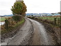
Farm track leading to Mains of Keithick
Looking south-eastward.
Image: © Peter Wood
Taken: 16 Nov 2019
0.16 miles
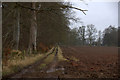
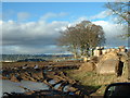
3
Fields at Keithick, south of Coupar Angus
Image: © Mike Pennington
Taken: 7 Apr 2013
0.21 miles
4
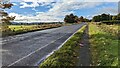
View of the A94 towards Burrelton and Woodside
Image: © Bartolo Creations
Taken: 1 Oct 2022
0.23 miles
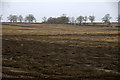
5
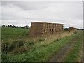
Stack, Mains of Keithick
A stack of big square straw bales beside the A94.
Image: © Richard Webb
Taken: 16 Sep 2012
0.24 miles
6
Caddam Farmland and Polytunnel Frames
Polytunnels are very common around here for growing soft fruit particularly Raspberry.
Image: © Chris Wilson
Taken: 3 Mar 2007
0.25 miles