IMAGES TAKEN NEAR TO
Coupar Angus, BLAIRGOWRIE, PH13 9LW
Introduction
This page details the photographs taken nearby to PH13 9LW by members of the Geograph project.
The Geograph project started in 2005 with the aim of publishing, organising and preserving representative images for every square kilometre of Great Britain, Ireland and the Isle of Man.

There are currently over 7.5m images from over14,400 individuals and you can help contribute to the project by visiting https://www.geograph.org.uk
Image Map
Images are licensed for reuse under creativecommons.org/licenses/by-sa/2.0
Notes
- Clicking on the map will re-center to the selected point.
- The higher the marker number, the further away the image location is from the centre of the postcode.
Image Listing (10 Images Found)
Images are licensed for reuse under creativecommons.org/licenses/by-sa/2.0
Image
Details
Distance
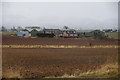
2
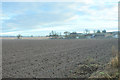
Covered fields
Fields near Campmuir covered in polythene.
Image: © Scott Cormie
Taken: 12 May 2018
0.16 miles
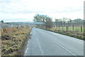
5
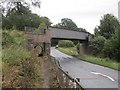
Railway bridge, Keithick
This bridge was rebuilt only a few years before the railway was finally closed in 1982.
Image: © Richard Webb
Taken: 16 Sep 2012
0.23 miles
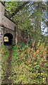
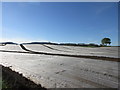
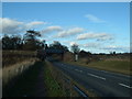
8

Bridge for Public Footpath on A94
Image: © Bartolo Creations
Taken: 15 Oct 2022
0.24 miles
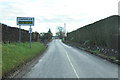
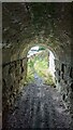
10
Old Rail Bridge
This bridge carries the dismantled Perth to Coupar Angus railway over the A94 north of Burrelton
Image: © Chris Wilson
Taken: 3 Mar 2007
0.25 miles