IMAGES TAKEN NEAR TO
Burrelton, BLAIRGOWRIE, PH13 9LG
Introduction
This page details the photographs taken nearby to PH13 9LG by members of the Geograph project.
The Geograph project started in 2005 with the aim of publishing, organising and preserving representative images for every square kilometre of Great Britain, Ireland and the Isle of Man.

There are currently over 7.5m images from over14,400 individuals and you can help contribute to the project by visiting https://www.geograph.org.uk
Image Map
Images are licensed for reuse under creativecommons.org/licenses/by-sa/2.0
Notes
- Clicking on the map will re-center to the selected point.
- The higher the marker number, the further away the image location is from the centre of the postcode.
Image Listing (5 Images Found)
Images are licensed for reuse under creativecommons.org/licenses/by-sa/2.0
Image
Details
Distance
1
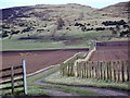
Farm track to Buttergask Hill
The track also acts as a footpath that allows walkers access to the hills.
Image: © Maigheach-gheal
Taken: 28 Mar 2010
0.06 miles
2
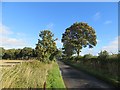
Long straight road
The road runs along most of the length of the Sidlaw Hills.
Image: © Richard Webb
Taken: 8 Oct 2013
0.15 miles
3
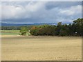
Stubble, Buttergask
After the spring barley harvest.
Image: © Richard Webb
Taken: 8 Oct 2013
0.18 miles