IMAGES TAKEN NEAR TO
Coupar Angus, BLAIRGOWRIE, PH13 9LD
Introduction
This page details the photographs taken nearby to PH13 9LD by members of the Geograph project.
The Geograph project started in 2005 with the aim of publishing, organising and preserving representative images for every square kilometre of Great Britain, Ireland and the Isle of Man.

There are currently over 7.5m images from over14,400 individuals and you can help contribute to the project by visiting https://www.geograph.org.uk
Image Map
Images are licensed for reuse under creativecommons.org/licenses/by-sa/2.0
Notes
- Clicking on the map will re-center to the selected point.
- The higher the marker number, the further away the image location is from the centre of the postcode.
Image Listing (10 Images Found)
Images are licensed for reuse under creativecommons.org/licenses/by-sa/2.0
Image
Details
Distance
1
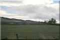
View of South Gask Farm
Picture taken from Campmuir / Abernyte Road just north of Gask Cottages.
Image: © Alan Morrison
Taken: 21 Feb 2009
0.10 miles
2
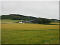
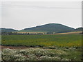
South Gask
Looking south to South Gask, with Gaskhill Wood on the northern flank of the Sidlaws beyond.
Image: © Scott Cormie
Taken: 17 Jul 2020
0.16 miles
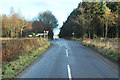
6
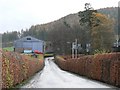
Beech hedges
The road into South Gask farm, lined by well-tended beech hedges.
Image: © James Allan
Taken: 27 Nov 2006
0.18 miles
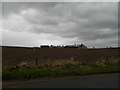
7
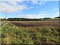
Potato field, South Gask
This field Image a few weeks later and after defoliation prior to lifting.
Image: © Richard Webb
Taken: 8 Oct 2013
0.19 miles
9
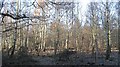
Balgove Wood
Contrary to the Ordnance Survey maps, the woodland to the north and east of the crossroads is deciduous.
Image: © Richard Webb
Taken: 29 Jan 2010
0.21 miles
10
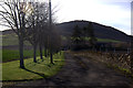
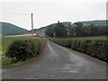
Track to Ford of Pitcur
Northballo Hill in the background.
Image: © Mike Pennington
Taken: 11 Apr 2014
0.25 miles