IMAGES TAKEN NEAR TO
Kettins, BLAIRGOWRIE, PH13 9JT
Introduction
This page details the photographs taken nearby to PH13 9JT by members of the Geograph project.
The Geograph project started in 2005 with the aim of publishing, organising and preserving representative images for every square kilometre of Great Britain, Ireland and the Isle of Man.

There are currently over 7.5m images from over14,400 individuals and you can help contribute to the project by visiting https://www.geograph.org.uk
Image Map
Images are licensed for reuse under creativecommons.org/licenses/by-sa/2.0
Notes
- Clicking on the map will re-center to the selected point.
- The higher the marker number, the further away the image location is from the centre of the postcode.
Image Listing (5 Images Found)
Images are licensed for reuse under creativecommons.org/licenses/by-sa/2.0
Image
Details
Distance
1
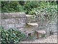
Stile, Baldowrie
Stone stile, unfortunately broken on the far side.
Image: © Richard Webb
Taken: 1 Sep 2007
0.01 miles
2
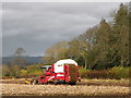
Getting the tatties in, Keillor
Harvesting potatoes at Keillor.
Image: © Maigheach-gheal
Taken: 31 Oct 2011
0.07 miles
3
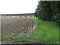
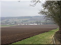
Potato field, Baldowrie
Potatoes just treated with sulphuric acid as a defoliant, prior to harvest.
Image: © Richard Webb
Taken: 1 Sep 2007
0.09 miles
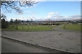
5
Keillor from the north-west
A distant view of Keillor from the minor road to the north-west.
Image: © Scott Cormie
Taken: 6 Apr 2018
0.17 miles