IMAGES TAKEN NEAR TO
Kettins, BLAIRGOWRIE, PH13 9JL
Introduction
This page details the photographs taken nearby to PH13 9JL by members of the Geograph project.
The Geograph project started in 2005 with the aim of publishing, organising and preserving representative images for every square kilometre of Great Britain, Ireland and the Isle of Man.

There are currently over 7.5m images from over14,400 individuals and you can help contribute to the project by visiting https://www.geograph.org.uk
Image Map
Images are licensed for reuse under creativecommons.org/licenses/by-sa/2.0
Notes
- Clicking on the map will re-center to the selected point.
- The higher the marker number, the further away the image location is from the centre of the postcode.
Image Listing (24 Images Found)
Images are licensed for reuse under creativecommons.org/licenses/by-sa/2.0
Image
Details
Distance
1
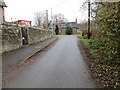
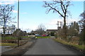
School Road in Kettins
Looking south-eastward.
Image: © Peter Wood
Taken: 16 Nov 2019
0.02 miles
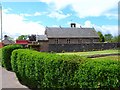
4
School Park, Kettins
As is quite common in Scotland, "Park" is here used as a street name
Image: © Oliver Dixon
Taken: 24 May 2006
0.05 miles
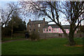
5
View of Kettins Bridge at Kettins village
The Kettins Burn runs under this bridge.
Image: © Alan Morrison
Taken: 21 Feb 2009
0.09 miles
6
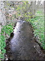
Kettins Burn
Kettins Burn from Kettins Bridge.
Image: © Maigheach-gheal
Taken: 11 Apr 2011
0.09 miles
8
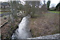
View of Kettins Burn looking upstream
Picture taken from Kettins Bridge within Kettins Village. Kettins Church can be seen at the top right.
Image: © Alan Morrison
Taken: 21 Feb 2009
0.09 miles
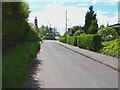
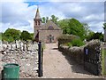
10
Roadway to Kettins Church
Entrance to the church at Kettins, viewed from near the bridge over the burn.
Image: © Scott Cormie
Taken: 12 May 2018
0.10 miles