IMAGES TAKEN NEAR TO
Newtyle Road, BLAIRGOWRIE, PH13 9JJ
Introduction
This page details the photographs taken nearby to Newtyle Road, PH13 9JJ by members of the Geograph project.
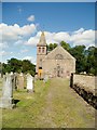
The Geograph project started in 2005 with the aim of publishing, organising and preserving representative images for every square kilometre of Great Britain, Ireland and the Isle of Man.

There are currently over 7.5m images from over14,400 individuals and you can help contribute to the project by visiting https://www.geograph.org.uk
Image Map
Images are licensed for reuse under creativecommons.org/licenses/by-sa/2.0
Notes
- Clicking on the map will re-center to the selected point.
- The higher the marker number, the further away the image location is from the centre of the postcode.
Image Listing (20 Images Found)
Images are licensed for reuse under creativecommons.org/licenses/by-sa/2.0
Image
Details
Distance
1
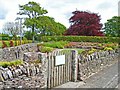
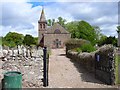
Kettins Community Garden
A beautiful community facility
Image: © Oliver Dixon
Taken: 24 May 2006
0.04 miles
2
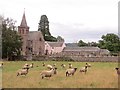
Sheep, Kettins
There has been a church on this site since the 13th century.
Image: © Richard Webb
Taken: 6 Sep 2013
0.08 miles
3
Maria Troon
This Flemish bell is named Maria Troon and was cast in Belgium in 1519. It has been the cause of much controversy over the years.
Image: © Maigheach-gheal
Taken: 5 Apr 2007
0.09 miles
4
Kettins Church
Kettins Church was founded in April 1249. The church stands on the site of one of six chapels established by a nearby Columban monastery. The present church dates from 1768, with the north wing added in 1870 and the tower in 1891.
Image: © Douglas Nelson
Taken: 9 Aug 2012
0.09 miles
5
Kettins Church
The church was built in 1768 and enlarged in 1870 and 1891.
Image: © Maigheach-gheal
Taken: 5 Apr 2007
0.10 miles
6
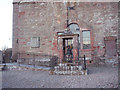
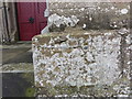
Bench Mark, Kettins
The lichen covered bench mark is found on the Parish Church. Image and http://www.bench-marks.org.uk/bm34270
A bench mark is an Ordnance Survey arrowhead sign found on walls, bridges, churches and specially erected triangulation pillars where the altitude above sea-level has been accurately measured by surveyors. The arrowhead points to a horizontal line above it which marks the exact altitude.
With rivets and pivots there is no datum (horizontal line) cut, the pointed-to horizontal surface defining the datum height.
Image: © Maigheach-gheal
Taken: 28 Mar 2010
0.11 miles
7
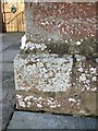
Ordnance Survey Cut Mark with Bolt
This lichen covered mark can be found on the wall of Kettins Parish Church. The benchmark's recorded height is 65.839 metres above sea level.
For more detail see : https://www.bench-marks.org.uk/bm34270
Image: © Peter Wood
Taken: 16 Nov 2019
0.11 miles
8
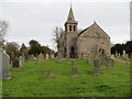
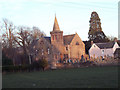
Kettins Parish Church and part of its burial ground
Viewed from the south-west.
Image: © Peter Wood
Taken: 16 Nov 2019
0.11 miles
9

Old Central Cross - moved to Kettins churchyard
Kettins Cross, old shaft in the churchyard, in parish of Kettins (Perth & Kinross District), Kettins parish church.
To be surveyed
Milestone Society National ID: PK_KET
Image: © Milestone Society
Taken: Unknown
0.12 miles