IMAGES TAKEN NEAR TO
Coupar Angus, BLAIRGOWRIE, PH13 9EZ
Introduction
This page details the photographs taken nearby to PH13 9EZ by members of the Geograph project.
The Geograph project started in 2005 with the aim of publishing, organising and preserving representative images for every square kilometre of Great Britain, Ireland and the Isle of Man.

There are currently over 7.5m images from over14,400 individuals and you can help contribute to the project by visiting https://www.geograph.org.uk
Image Map
Images are licensed for reuse under creativecommons.org/licenses/by-sa/2.0
Notes
- Clicking on the map will re-center to the selected point.
- The higher the marker number, the further away the image location is from the centre of the postcode.
Image Listing (5 Images Found)
Images are licensed for reuse under creativecommons.org/licenses/by-sa/2.0
Image
Details
Distance
2
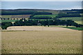
Fields at West Ardler
Looking towards Upper Ballunie.
Image: © Mike Pennington
Taken: 30 Jul 2010
0.12 miles
3
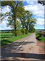
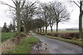
Tree-lined road from Ardler to Keillor
Many of the roads in Strathmore are flanked by trees, usually on both sides. Here, the trees flank one side of the road only.
Image: © Oliver Dixon
Taken: 24 May 2006
0.13 miles
4
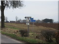
Direction signs
Multitude of direction signs west of Ardler, with West Ardler beyond.
Image: © Scott Cormie
Taken: 6 Apr 2018
0.15 miles
5
West Ardler
Tree lined roads are common in Strathmore.
Image: © Richard Webb
Taken: 29 Mar 2015
0.23 miles