IMAGES TAKEN NEAR TO
George Street, BLAIRGOWRIE, PH13 9DH
Introduction
This page details the photographs taken nearby to George Street, PH13 9DH by members of the Geograph project.
The Geograph project started in 2005 with the aim of publishing, organising and preserving representative images for every square kilometre of Great Britain, Ireland and the Isle of Man.

There are currently over 7.5m images from over14,400 individuals and you can help contribute to the project by visiting https://www.geograph.org.uk
Image Map
Images are licensed for reuse under creativecommons.org/licenses/by-sa/2.0
Notes
- Clicking on the map will re-center to the selected point.
- The higher the marker number, the further away the image location is from the centre of the postcode.
Image Listing (76 Images Found)
Images are licensed for reuse under creativecommons.org/licenses/by-sa/2.0
Image
Details
Distance
1
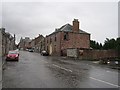
George Street
The old main road through Coupar Angus.
Image: © Richard Webb
Taken: 16 Sep 2012
0.03 miles
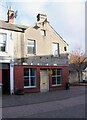
2
Assembly Room
Now under renovation which is good news in a town with more than its fair share of closed businesses.
Image: © Richard Webb
Taken: 16 Sep 2012
0.03 miles
3
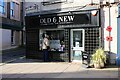
Old & New
Gift shop at The Cross, Coupar Angus. 'Something for everyone'.
Image: © Richard Sutcliffe
Taken: 31 Oct 2023
0.03 miles
4
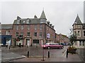
The Cross, Coupar Angus
The building on the right is the former Royal Hotel and Assembly Rooms, dating from about 1840 and Category B listed https://portal.historicenvironment.scot/designation/LB23138. The cross in the centre is a modern version.
Image: © Richard Sutcliffe
Taken: 31 Oct 2023
0.03 miles
5
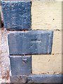
Bench Mark, Couper Angus
The bench mark is on the former Royal Hotel. For a wider view see Image and http://www.bench-marks.org.uk/bm34323
A bench mark is an Ordnance Survey arrowhead sign found on walls, bridges, churches and specially erected triangulation pillars where the altitude above sea-level has been accurately measured by surveyors. The arrowhead points to a horizontal line above it which marks the exact altitude.
With rivets and pivots there is no datum (horizontal line) cut, the pointed-to horizontal surface defining the datum height.
Image: © Maigheach-gheal
Taken: 31 Mar 2010
0.04 miles
6
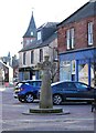
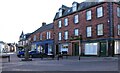
The Cross, Coupar Angus
A modern version of the traditional town cross in the High Street.
Image: © Richard Sutcliffe
Taken: 31 Oct 2023
0.04 miles
7
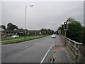
A94, Coupar Angus
A newish road, built on the Caledonian Railway trackbed.
Image: © Richard Webb
Taken: 16 Sep 2012
0.04 miles
8
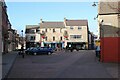
High Street, Coupar Angus
Looking towards shops at The Cross Image
Image: © Richard Sutcliffe
Taken: 31 Oct 2023
0.04 miles
9
The High Street Store
Before 2016 this was Meg's Snack Bar and had been empty for some time. It was bought by Forward Coupar Angus and developed as a community shop, dedicated to selling local products and opened in June 2016. The property is currently empty and according to the sign outside it was for sale, but is currently 'under offer'.
Image: © Richard Sutcliffe
Taken: 31 Oct 2023
0.05 miles
10
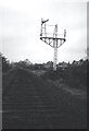
Dismantling the Caledonian Railway
In Coupar Angus. Taken on the way to a football match in Brechin. The trackbed is now the A94. Image
Image: © Richard Webb
Taken: 1 May 1983
0.05 miles