IMAGES TAKEN NEAR TO
Precinct Street, BLAIRGOWRIE, PH13 9DG
Introduction
This page details the photographs taken nearby to Precinct Street, PH13 9DG by members of the Geograph project.
The Geograph project started in 2005 with the aim of publishing, organising and preserving representative images for every square kilometre of Great Britain, Ireland and the Isle of Man.

There are currently over 7.5m images from over14,400 individuals and you can help contribute to the project by visiting https://www.geograph.org.uk
Image Map
Images are licensed for reuse under creativecommons.org/licenses/by-sa/2.0
Notes
- Clicking on the map will re-center to the selected point.
- The higher the marker number, the further away the image location is from the centre of the postcode.
Image Listing (70 Images Found)
Images are licensed for reuse under creativecommons.org/licenses/by-sa/2.0
Image
Details
Distance
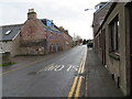
1
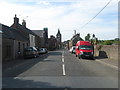
The road heading back to Coupar Angus town centre
Image: © James Denham
Taken: 3 Jun 2010
0.02 miles
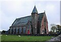
2
St. Mary's Catholic Church
St. Mary's Catholic Church in Queen Street, Coupar Angus.
Image: © Scott Cormie
Taken: 16 Apr 2017
0.04 miles
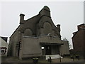
3
St Mary's Catholic Church
On Queen Street, Coupar Angus. Originally built as a United Free Church, it then became the Picture Playhouse Cinema from the 1940s (?) until the late 1960s. It later reverted to being a church again, and is now St Mary's Roman Catholic Church.
Image: © Richard Sutcliffe
Taken: 31 Oct 2023
0.04 miles
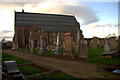
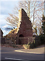
4
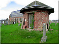
Abbey Church watch house
This watch house was built in 1822 as a shelter for those guarding newly buried corpses against the activities of grave-robbers. Human corpses were in great demand at that time for use in anatomy schools.
Image: © Martyn Gorman
Taken: 9 Apr 2007
0.05 miles
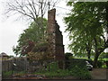
5
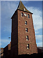
The Steeple
The Steeple, or tolbooth tower, was built by public subscription in 1762 and completed in 1796. The Steeple was to serve as a gaol on the ground floor and as a meeting house for local courts on the upper floor. Although a partial ruin, much of the original Steeple remains.
Image: © Maigheach-gheal
Taken: 10 Apr 2007
0.05 miles
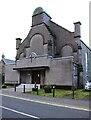
6
Abbey Church, Coupar Angus
On Queen Street. Dating from 1859-60, it is Category B listed https://portal.historicenvironment.scot/designation/LB23126.
Image: © Richard Sutcliffe
Taken: 31 Oct 2023
0.05 miles
7
Queen Street (A923) in Coupar Angus
Looking south-eastward.
Image: © Peter Wood
Taken: 16 Nov 2019
0.05 miles
8
Coupar Angus Church
Church of Scotland church, believed to built on the site of the former abbey's church.
Image: © Mike Pennington
Taken: 8 Apr 2014
0.06 miles
10
Remains of the Abbey at Coupar Angus
The remaining part of Coupar Angus Abbey from across Dundee Road.
Image: © Scott Cormie
Taken: 21 May 2017
0.06 miles