IMAGES TAKEN NEAR TO
Hill Garden, BLAIRGOWRIE, PH13 9AX
Introduction
This page details the photographs taken nearby to Hill Garden, PH13 9AX by members of the Geograph project.
The Geograph project started in 2005 with the aim of publishing, organising and preserving representative images for every square kilometre of Great Britain, Ireland and the Isle of Man.

There are currently over 7.5m images from over14,400 individuals and you can help contribute to the project by visiting https://www.geograph.org.uk
Image Map
Images are licensed for reuse under creativecommons.org/licenses/by-sa/2.0
Notes
- Clicking on the map will re-center to the selected point.
- The higher the marker number, the further away the image location is from the centre of the postcode.
Image Listing (55 Images Found)
Images are licensed for reuse under creativecommons.org/licenses/by-sa/2.0
Image
Details
Distance
1
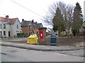
Residential area, Coupar Angus
A George VI reign postbox in a residential area of the town.
Image: © Maigheach-gheal
Taken: 31 Mar 2010
0.03 miles
2
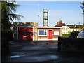
Coupar Angus Community Fire Station
The fire station in Coupar Angus, viewed from Blairgowrie Road.
Image: © Scott Cormie
Taken: 12 May 2018
0.05 miles
4
St.Anne's Episcopal Church
St.Anne's Episcopal Church on Forfar Road, Coupar Angus.
Image: © Scott Cormie
Taken: 12 May 2018
0.12 miles
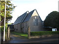
5
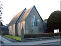
St Anne's Episcopal Church, Coupar Angus
The church stands beside the A94, Forfar Road.
Image: © Maigheach-gheal
Taken: 27 Mar 2010
0.12 miles
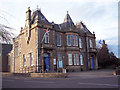
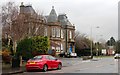
6
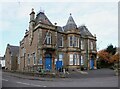
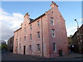
Coupar Angus Town Hall
Designed by David Smart and built 1886-7 on Union Street, Coupar Angus to mark Queen Victoria's jubilee. The building's future has been in doubt in recent years as Perth & Kinross Council struggle to find funding for essential maintenance work. It is Category C listed https://portal.historicenvironment.scot/designation/LB51347.
Image: © Richard Sutcliffe
Taken: 31 Oct 2023
0.12 miles
8
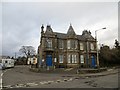
H?tel de Ville
Coupar Angus' rather French looking town hall.
Image: © Richard Webb
Taken: 22 Feb 2014
0.12 miles
9
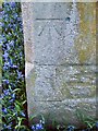
Bench Mark, St Anne's Church
For a wider view of the church Image and http://www.bench-marks.org.uk/bm33567
A bench mark is an Ordnance Survey arrowhead sign found on walls, bridges, churches and specially erected triangulation pillars where the altitude above sea-level has been accurately measured by surveyors. The arrowhead points to a horizontal line above it which marks the exact altitude.
With rivets and pivots there is no datum (horizontal line) cut, the pointed-to horizontal surface defining the datum height.
Image: © Maigheach-gheal
Taken: 27 Mar 2010
0.13 miles
10
Cumberland Barracks
The Cumberland or Yeomanry Barracks were restored by the Burgh Council in 1974.
Image: © Maigheach-gheal
Taken: 12 Apr 2011
0.13 miles