IMAGES TAKEN NEAR TO
Blairgowrie Road, BLAIRGOWRIE, PH13 9AU
Introduction
This page details the photographs taken nearby to Blairgowrie Road, PH13 9AU by members of the Geograph project.
The Geograph project started in 2005 with the aim of publishing, organising and preserving representative images for every square kilometre of Great Britain, Ireland and the Isle of Man.

There are currently over 7.5m images from over14,400 individuals and you can help contribute to the project by visiting https://www.geograph.org.uk
Image Map
Images are licensed for reuse under creativecommons.org/licenses/by-sa/2.0
Notes
- Clicking on the map will re-center to the selected point.
- The higher the marker number, the further away the image location is from the centre of the postcode.
Image Listing (15 Images Found)
Images are licensed for reuse under creativecommons.org/licenses/by-sa/2.0
Image
Details
Distance
2
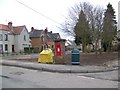
Residential area, Coupar Angus
A George VI reign postbox in a residential area of the town.
Image: © Maigheach-gheal
Taken: 31 Mar 2010
0.13 miles
6
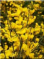
Broom at Coupar Angus
Broom is a tall deciduous shrub with small simple leaves. Scented golden yellow flowers in leafy spikes from April to June. Found in dry sunny habitats, roadside verges, clearings and woodland edges.
Image: © Maigheach-gheal
Taken: 29 May 2008
0.15 miles
7
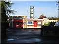
Coupar Angus Community Fire Station
The fire station in Coupar Angus, viewed from Blairgowrie Road.
Image: © Scott Cormie
Taken: 12 May 2018
0.17 miles
8
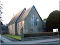
St Anne's Episcopal Church, Coupar Angus
The church stands beside the A94, Forfar Road.
Image: © Maigheach-gheal
Taken: 27 Mar 2010
0.21 miles
9
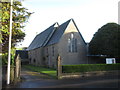
St.Anne's Episcopal Church
St.Anne's Episcopal Church on Forfar Road, Coupar Angus.
Image: © Scott Cormie
Taken: 12 May 2018
0.21 miles
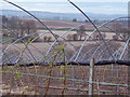
10
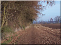
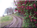
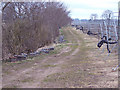
Field Path
The path runs beside a field recently planted with potatoes.
Image: © Maigheach-gheal
Taken: 2 Apr 2007
0.21 miles