IMAGES TAKEN NEAR TO
Fortingall Place, PERTH, PH1 2NQ
Introduction
This page details the photographs taken nearby to Fortingall Place, PH1 2NQ by members of the Geograph project.
The Geograph project started in 2005 with the aim of publishing, organising and preserving representative images for every square kilometre of Great Britain, Ireland and the Isle of Man.

There are currently over 7.5m images from over14,400 individuals and you can help contribute to the project by visiting https://www.geograph.org.uk
Image Map
Images are licensed for reuse under creativecommons.org/licenses/by-sa/2.0
Notes
- Clicking on the map will re-center to the selected point.
- The higher the marker number, the further away the image location is from the centre of the postcode.
Image Listing (6 Images Found)
Images are licensed for reuse under creativecommons.org/licenses/by-sa/2.0
Image
Details
Distance
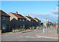
3
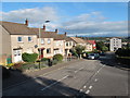
Garth Avenue in Letham
I used to spend holidays in this street with my stepmum's parents during the 70s.
Image: © william
Taken: 8 Sep 2011
0.19 miles
5
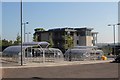
Behind the Bike Sheds
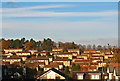
New student accommodation at Perth College. During the summer of 2011 it was being put to good use as a youth hostel by the S.Y.H.A.
Image: © K A
Taken: 3 Jul 2011
0.23 miles
6
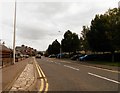
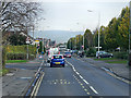
Struan Rd in Letham
At the junction with Garth Avenue.
Image: © william
Taken: 8 Sep 2011
0.24 miles