IMAGES TAKEN NEAR TO
Feus Road, PERTH, PH1 2AS
Introduction
This page details the photographs taken nearby to Feus Road, PH1 2AS by members of the Geograph project.
The Geograph project started in 2005 with the aim of publishing, organising and preserving representative images for every square kilometre of Great Britain, Ireland and the Isle of Man.

There are currently over 7.5m images from over14,400 individuals and you can help contribute to the project by visiting https://www.geograph.org.uk
Image Map
Images are licensed for reuse under creativecommons.org/licenses/by-sa/2.0
Notes
- Clicking on the map will re-center to the selected point.
- The higher the marker number, the further away the image location is from the centre of the postcode.
Image Listing (23 Images Found)
Images are licensed for reuse under creativecommons.org/licenses/by-sa/2.0
Image
Details
Distance
3
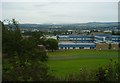
View Over Perth
Taken from Cherrybank
Image: © John MacKenzie
Taken: 14 Sep 2008
0.11 miles
5

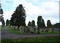
Wellshill cemetery
Gravestones in Wellshill cemetery, some unstable and near to collapse.
Image: © William Starkey
Taken: 10 Dec 2013
0.13 miles
7
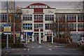
Commercial building
This art deco style building is situated on St Catherine's Road. Formerly government offices, it is now used for commercial purposes.
Image: © Paul McIlroy
Taken: 26 Dec 2007
0.16 miles
8

Perth fire station
Perth fire station, 401 High Street, Perth, Tayside
Image: © Kevin Hale
Taken: 31 Jul 2010
0.16 miles
9
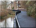
The Lade Walkway
This footpath runs alongside the Town Lade Image The buildings on the right are at the end of Ballantine Place.
Image: © Paul McIlroy
Taken: 26 Dec 2007
0.16 miles
10
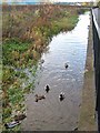
Town Lade
The Town Lade is known to have been in existence by the 12th century, although the exact date of its construction is not known. It carries water from the river Almond via a sluice at Almondbank, four miles north west of Perth. The lade runs through the town, discharging into the Tay just below Perth Bridge. Several conduits lead from it which once powered water wheels for grinding meal and corn. A walkway runs alongside it for much of its length; this section runs past the retail park.
Image: © Lis Burke
Taken: 2 Dec 2007
0.17 miles