IMAGES TAKEN NEAR TO
Bulb Park, BLAIRGOWRIE, PH12 8UZ
Introduction
This page details the photographs taken nearby to Bulb Park, PH12 8UZ by members of the Geograph project.
The Geograph project started in 2005 with the aim of publishing, organising and preserving representative images for every square kilometre of Great Britain, Ireland and the Isle of Man.

There are currently over 7.5m images from over14,400 individuals and you can help contribute to the project by visiting https://www.geograph.org.uk
Image Map
Images are licensed for reuse under creativecommons.org/licenses/by-sa/2.0
Notes
- Clicking on the map will re-center to the selected point.
- The higher the marker number, the further away the image location is from the centre of the postcode.
Image Listing (16 Images Found)
Images are licensed for reuse under creativecommons.org/licenses/by-sa/2.0
Image
Details
Distance
1
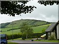
Bulb Park houses
With Kinpurney Hill and tower in the background.
Image: © James Allan
Taken: 13 Jun 2011
0.03 miles
2
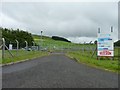
Gate of sewage works
Entry to Newtyle sewage works off Bulb Park road.
Image: © James Allan
Taken: 13 Jun 2011
0.09 miles
3
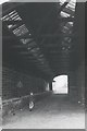
The Original Newtyle Station
This was the north terminus for the Dundee to Newtyle Railway which was built in the 1830s. It was later used as a Goods Station and by the 1960s as a potato store.
Image: © Elliott Simpson
Taken: Unknown
0.13 miles
4
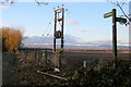
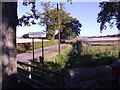
Signpost Depicting walks in Newtyle
The sign reasonably straight ahead depicts the Railway Walk, and the pointer to the right depicts The Den and Kinpurnie Observatory. Photo taken from North Street, Newtyle.
Image: © Alan Morrison
Taken: 1 Mar 2009
0.13 miles
5
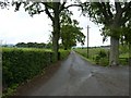
Private Road to Burnmouth Farm
Alongside Newtyle Burn, from the minor road out of Newtyle.
Image: © Stanley Howe
Taken: 8 Oct 2015
0.18 miles
6
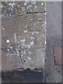
Bench Mark, Church Street
The mark is on the south-east angle of the hall on Church Street. For a wider view Image and http://www.bench-marks.org.uk/bm34345
A bench mark is an Ordnance Survey arrowhead sign found on walls, bridges, churches and specially erected triangulation pillars where the altitude above sea-level has been accurately measured by surveyors. The arrowhead points to a horizontal line above it which marks the exact altitude.
With rivets and pivots there is no datum (horizontal line) cut, the pointed-to horizontal surface defining the datum height.
Image: © Maigheach-gheal
Taken: 1 Apr 2010
0.21 miles
7
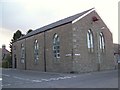
Hall, Newtyle
The hall is on the junction of Church Street and Castle Street. There is a bench mark on the south east angle.
Image: © Maigheach-gheal
Taken: 1 Apr 2010
0.21 miles
8
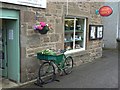
The post boy's bike
Parked at the door of Newtyle Post Office the bicycle now has its carrier full of plants instead of parcels.
Image: © James Allan
Taken: 9 Aug 2010
0.21 miles
10
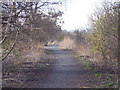
Former railway line near Newtyle
The former railway line is now a waymarked walk.
Image: © Maigheach-gheal
Taken: 5 Apr 2007
0.24 miles