IMAGES TAKEN NEAR TO
Meigle, BLAIRGOWRIE, PH12 8TQ
Introduction
This page details the photographs taken nearby to PH12 8TQ by members of the Geograph project.
The Geograph project started in 2005 with the aim of publishing, organising and preserving representative images for every square kilometre of Great Britain, Ireland and the Isle of Man.

There are currently over 7.5m images from over14,400 individuals and you can help contribute to the project by visiting https://www.geograph.org.uk
Image Map
Images are licensed for reuse under creativecommons.org/licenses/by-sa/2.0
Notes
- Clicking on the map will re-center to the selected point.
- The higher the marker number, the further away the image location is from the centre of the postcode.
Image Listing (8 Images Found)
Images are licensed for reuse under creativecommons.org/licenses/by-sa/2.0
Image
Details
Distance
1

Meigle Cricket Club
The pavilion with Cat Law beyond.
Image: © Richard Webb
Taken: 16 May 2010
0.16 miles
2

Victory Park, Meigle
Meigle 2nd XI playing Freuchie. Freuchie winning by six wickets.
Image: © Richard Webb
Taken: 16 May 2010
0.17 miles
3
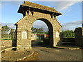
Meigle War Memorial
The war memorial at Meigle, taking the form of an arched entrance to Victory Park, on Ardler Road.
Image: © Scott Cormie
Taken: 24 May 2020
0.20 miles
4
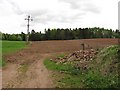
Farmland, Belmont Castle
Not an orchard as marked on the 1:50 000 map.
Image: © Richard Webb
Taken: 16 May 2010
0.23 miles
5
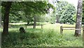
Standing stone, Belmont Castle
A small stone in the parkland viewed from the track from the south-west gatehouse to the estate.
Image: © Bob Embleton
Taken: 25 Jun 2010
0.23 miles
6

Farmland, Belmont
Freshly tilled Strathmore soil with a view over to Cat Law.
Image: © Richard Webb
Taken: 16 May 2010
0.24 miles
7
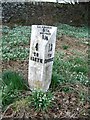
Milepost, Meigle
The milepost stands amongst the snowdrops beside the B954.
Mileposts/stones are the original roadside heritage features with many dating back hundreds of years and these historic items are under threat from highway developments.
Mileposts/stones did not come into general use until the Turnpike Act of 1766 made them compulsory on turnpike roads, these roads were built by private enterprise under licence from the Government and maintained by tolls on those who used them. Before this Act milestones were put up occasionally, often as charitable acts and commemorations. Many Turnpike Act stones still exist. They are usually 2-3 ft high, with the initial letter or abbreviation of the nearest market town show on two faces, and the distance from it.
In sheltered places the snowdrop begins to flower at Christmas, and in other parts it is welcomed as one of the first signs of spring, flowering from January to March.
The drooping, bell-shaped flowers have six segments - three white ones outside the flower and three tipped with a bright spot inside it.
It is doubtful whether the snowdrop (Galanthus nivalis) is a native of Britain. It was probably introduced in medieval times from central Europe and it is rare in Ireland.
Image: © Maigheach-gheal
Taken: 28 Mar 2010
0.25 miles
8
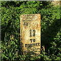
B954 Milestone at Meigle
Close up of the cast-iron milestone on the B954 Dundee Road on the south side of Meigle.
Image: © Scott Cormie
Taken: 24 May 2020
0.25 miles