IMAGES TAKEN NEAR TO
Meigle, BLAIRGOWRIE, PH12 8RD
Introduction
This page details the photographs taken nearby to PH12 8RD by members of the Geograph project.
The Geograph project started in 2005 with the aim of publishing, organising and preserving representative images for every square kilometre of Great Britain, Ireland and the Isle of Man.

There are currently over 7.5m images from over14,400 individuals and you can help contribute to the project by visiting https://www.geograph.org.uk
Image Map
Images are licensed for reuse under creativecommons.org/licenses/by-sa/2.0
Notes
- Clicking on the map will re-center to the selected point.
- The higher the marker number, the further away the image location is from the centre of the postcode.
Image Listing (7 Images Found)
Images are licensed for reuse under creativecommons.org/licenses/by-sa/2.0
Image
Details
Distance
1
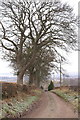
Track at Simprim, between Meigle and Ruthven
Image: © Mike Pennington
Taken: 1 Jan 2009
0.03 miles
3
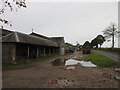
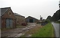
Buildings at Simprim
The farm buildings at Simprim adjacent to the roadside.
Image: © Scott Cormie
Taken: 14 Oct 2018
0.09 miles
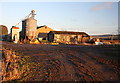
5
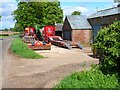
Simprim Farm, near Meigle
Mixed arable farm and agricultural contractors
Image: © Oliver Dixon
Taken: 24 May 2006
0.13 miles
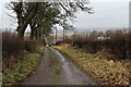
6
Simprim in the rain
Traffic goes surprisingly fast on this narrow road, probably because it is a long straight stretch.
Image: © Lis Burke
Taken: 5 Aug 2007
0.13 miles
7
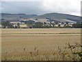
Barley, Simprim
View across Strathmore towards Kinpurney Hill.
Image: © Richard Webb
Taken: 16 Sep 2015
0.20 miles